


2013-04-27 Rando CVA Dordogne

holtzv
User GUIDE
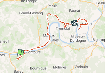

Length
30 km

Max alt
188 m

Uphill gradient
550 m
Km-Effort
37 km

Min alt
39 m

Downhill gradient
626 m
Boucle
No
Creation date :
2014-12-10 00:00:00.0
Updated on :
2014-12-10 00:00:00.0
4h35
Difficulty : Medium

FREE GPS app for hiking
 SityTrail
IGN / Geographical institutes
SityTrail Plus
The world is yours!
About
Trail Equestrian of 30 km to be discovered at New Aquitaine, Dordogne, Couze-et-Saint-Front. This trail is proposed by holtzv.
Description
Départ : La Ferme du Peytavit
Arrivée : La Haute Yerle

Positioning
Country:
France
Region :
New Aquitaine
Department/Province :
Dordogne
Municipality :
Couze-et-Saint-Front
Location:
Unknown
Start:(Dec)
Start:(UTM)
319966 ; 4966004 (31T) N.
Comments
