Trail Walking Gurcy-le-Châtel - SLV-130112 - (AMAJ) Chalautre-Gurcy - Photo

SLV-130112 - (AMAJ) Chalautre-Gurcy

 randodan
randodan

User

© OpenStreetMap contributors
Length
Length
15.6 km
Max alt
Max alt
145 m
Uphill gradient
Uphill gradient
250 m
Km-Effort
Km-Effort  
18.9 km
Min alt
Min alt
74 m
Downhill gradient
Downhill gradient
252 m
Boucle
Boucle
Yes
Creation date :
2014-12-10 00:00:00.0
Updated on :
2014-12-10 00:00:00.0

(1 Reviews)

Walking
Walking
4h09
Difficulty : Unknown

Scan this QR Code to open this trail in the SityTrail application

FREE GPS app for hiking

Logo SityTrail SityTrail

IGN / Geographical institutes

Download SityTrail from the App Store Download SityTrail from Google Play

Logo SityTrail SityTrail World

The world is yours!

Download SityTrail from the App Store Download SityTrail from Google Play Download SityTrail on Huawei AppGallery

About

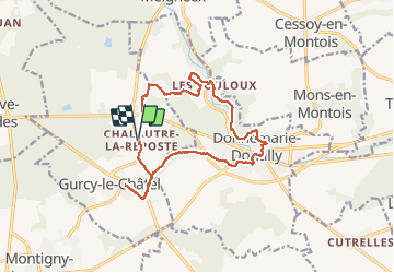
Trail Walking of 15.6 km to be discovered at Ile-de-France, Seine-et-Marne, Gurcy-le-Châtel. This trail is proposed by randodan.

Elevation profile

Positioning

Country:
France
Region :
Ile-de-France
Department/Province :
Seine-et-Marne
Municipality :
Gurcy-le-Châtel
Location:
Unknown
Start:(UTM)
506786 ; 5369744 (31U) N.

Comments

Please log in to post a review or rate the element


Gucy-Le-Châtel (77)


Trails nearby

Trail On foot Donnemarie-Dontilly - Montereau - Donnemarie Dontilly Linéaire 30 km - Photo
On foot
chessyca

On foot

Difficult
Donnemarie-Dontilly, Ile-de-France, Seine-et-Marne, France
31 km | 38 km-effort
8h 31min
No
Trail Walking Montigny-Lencoup - Boucle Montigny Lencoup - Donnemarie 30 km - Photo
Walking
chessyca

Walking

Very difficult
Montigny-Lencoup, Ile-de-France, Seine-et-Marne, France
30 km | 35 km-effort
6h 6min
Yes
Trail Walking Donnemarie-Dontilly - Boucle autour de Donnemarie Dontilly  - Photo
Walking
BrunoMounier

Walking

Difficult
Donnemarie-Dontilly, Ile-de-France, Seine-et-Marne, France
11.4 km | 14.1 km-effort
2h 9min
Yes
Trail Walking Montigny-Lencoup - Boucle Montigny Lencoup - Donnemarie - Dontilly - Preuilly  - Photo
Walking
chessyca

Walking

Easy
Montigny-Lencoup, Ile-de-France, Seine-et-Marne, France
33 km | 39 km-effort
6h 34min
Yes
Trail Walking Montigny-Lencoup - Boucle Montigny Lencoup - Donnemarie - Sigy  - Photo
Walking
chessyca

Walking

Medium
Montigny-Lencoup, Ile-de-France, Seine-et-Marne, France
32 km | 38 km-effort
5h 59min
No
Trail Walking Mons-en-Montois - Mons en montois 77 - Photo
Walking
raypat

Walking

Very easy
Mons-en-Montois, Ile-de-France, Seine-et-Marne, France
21 km | 25 km-effort
5h 14min
Yes
Trail Walking Donnemarie-Dontilly - DD4-9-2013 - Photo
Walking
Gessay

Walking

Very easy
Donnemarie-Dontilly, Ile-de-France, Seine-et-Marne, France
4.9 km | 6.2 km-effort
1h 5min
Yes
Trail Walking Gurcy-le-Châtel - 2013-01-12_chalautre - Photo
Walking
jcm17

Walking

Easy
(1)
Gurcy-le-Châtel, Ile-de-France, Seine-et-Marne, France
14.3 km | 17.5 km-effort
3h 48min
Yes
Trail Walking Donnemarie-Dontilly - Donemarie  - Photo
Walking
Gessay

Walking

Very easy
Donnemarie-Dontilly, Ile-de-France, Seine-et-Marne, France
5.4 km | 6.6 km-effort
1h 33min
Yes


Close
My subscriptions