Trail Walking Saint-Didier-sur-Doulon - vulcanboy-2013-J2 - Photo
 vulcanoo
vulcanoo

User

© OpenStreetMap contributors
Length
Length
27 km
Max alt
Max alt
1166 m
Uphill gradient
Uphill gradient
1143 m
Km-Effort
Km-Effort  
41 km
Min alt
Min alt
602 m
Downhill gradient
Downhill gradient
676 m
Boucle
Boucle
No
Creation date :
2014-12-10 00:00:00.0
Updated on :
2014-12-10 00:00:00.0

(0 Reviews)

Walking
Walking
8h17
Difficulty : Medium

Scan this QR Code to open this trail in the SityTrail application

FREE GPS app for hiking

Logo SityTrail SityTrail

IGN / Geographical institutes

Download SityTrail from the App Store Download SityTrail from Google Play

Logo SityTrail SityTrail World

The world is yours!

Download SityTrail from the App Store Download SityTrail from Google Play Download SityTrail on Huawei AppGallery

About

Trail Walking of 27 km to be discovered at Auvergne-Rhône-Alpes, Haute-Loire, Saint-Didier-sur-Doulon. This trail is proposed by vulcanoo.

Description

saint sur doulonsambadel

Elevation profile

Points of interest

Point of interest Saint-Didier-sur-Doulon - OR-2062888:Rando-2013-j2 26.024  - Photo
vulcanoo
SAINT-DIDIER-SUR-DOULON 

Positioning

Country:
France
Region :
Auvergne-Rhône-Alpes
Department/Province :
Haute-Loire
Municipality :
Saint-Didier-sur-Doulon
Location:
Unknown
Start:(Dec)
Start:(UTM)
542282 ; 5016546 (31T) N.

Trails nearby

Trail Walking Berbezit - Autour de Berbezit - Photo
Walking
yew

Walking

Medium
Berbezit, Auvergne-Rhône-Alpes, Haute-Loire, France
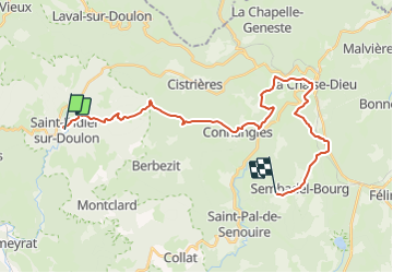
19.9 km | 29 km-effort
5h 0min
Yes
Trail Walking Chaniat - la Rochette.gpx - Photo
Walking
LaBreq

Walking

Very easy
Chaniat, Auvergne-Rhône-Alpes, Haute-Loire, France
6.3 km | 9 km-effort
1h 29min
Yes
Trail Horseback riding Frugières-le-Pin - rando vero 10 03 2024 - Photo
Horseback riding
pugnet

Horseback riding

Very difficult
Frugières-le-Pin, Auvergne-Rhône-Alpes, Haute-Loire, France
114 km | 141 km-effort
12h 44min
No
Trail Other activity Vals-le-Chastel - Vals le chastel javaugues 2013 - Photo
Other activity
thierrychanudet

Other activity

Very easy
Vals-le-Chastel, Auvergne-Rhône-Alpes, Haute-Loire, France
10.7 km | 15.5 km-effort
1h 0min
No
Trail Other activity Cistrières - alex. chaise dieu - Photo
Other activity
thierrychanudet

Other activity

Very easy
Cistrières, Auvergne-Rhône-Alpes, Haute-Loire, France
81 km | 121 km-effort
4h 17min
Yes
Trail Walking Cistrières - Montel vintz - Photo
Walking
thierrychanudet

Walking

Difficult
(1)
Cistrières, Auvergne-Rhône-Alpes, Haute-Loire, France
6.7 km | 11.5 km-effort
1h 45min
No
Trail Other activity Javaugues - 2014 Javaugues à Pierre plantée par lavaudieu Pierre Planée - Photo
Other activity
thierrychanudet

Other activity

Very easy
Javaugues, Auvergne-Rhône-Alpes, Haute-Loire, France
49 km | 72 km-effort
5min
No
Trail Equestrian Frugières-le-Pin - A cheval autour de Frugières le Pin - Photo
Equestrian
tracegps

Equestrian

Medium
Frugières-le-Pin, Auvergne-Rhône-Alpes, Haute-Loire, France
16.5 km | 21 km-effort
2h 30min
Yes
Trail Walking Montclard - montclard - Photo
Walking
boyer43

Walking

Very easy
Montclard, Auvergne-Rhône-Alpes, Haute-Loire, France
14.5 km | 0 m-effort
Unknown
Yes


Close
My subscriptions