Trail Walking Berbezit - Autour de Berbezit - Photo
 yew
yew

User

© OpenStreetMap contributors
Length
Length
19.9 km
Max alt
Max alt
983 m
Uphill gradient
Uphill gradient
713 m
Km-Effort
Km-Effort  
29 km
Min alt
Min alt
671 m
Downhill gradient
Downhill gradient
712 m
Boucle
Boucle
Yes
Creation date :
2016-10-31 00:00:00.0
Updated on :
2016-10-31 00:00:00.0

(0 Reviews)

Walking
Walking
5h00
Difficulty : Medium

Scan this QR Code to open this trail in the SityTrail application

FREE GPS app for hiking

Logo SityTrail SityTrail

IGN / Geographical institutes

Download SityTrail from the App Store Download SityTrail from Google Play

Logo SityTrail SityTrail World

The world is yours!

Download SityTrail from the App Store Download SityTrail from Google Play Download SityTrail on Huawei AppGallery

About

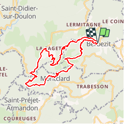
Trail Walking of 19.9 km to be discovered at Auvergne-Rhône-Alpes, Haute-Loire, Berbezit. This trail is proposed by yew.

Description

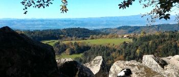
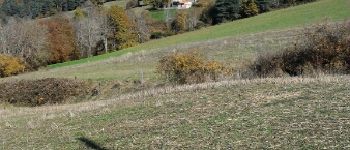
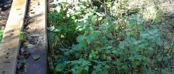
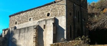
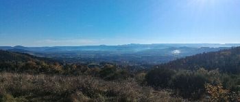
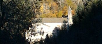
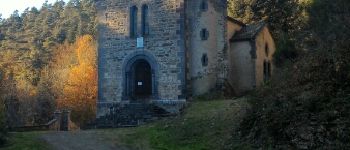
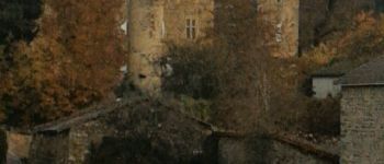
Tracé sur la base de plusieurs PR (marque jaune). Fait en automne. Assez sportif du fait de la succession de descentes et montées sur un terrain mixte avec parfois de la boue, des ruisseaux, des pierres qui roulent sous les pas, et des raidillons. Belle ballade olfactive dans les bois, et visuelles dans les vallées avec des points de vus sur le Puy de Dôme et le Cantal. Ruines de moulin, fermes anciennes, villages perdus, chapelle et église cachées, château... Fontaine à Liotour et à Berbezit sans garantie de potabilité.

Elevation profile

Photos

Points of interest

Point of interest Berbezit - Belle fourmilière - Photo
yew
Point of interest Saint-Didier-sur-Doulon - ferme ancienne - Photo
yew
SAINT-DIDIER-SUR-DOULON 
Point of interest Saint-Didier-sur-Doulon - gué et ruines d'un moulin - Photo
yew
SAINT-DIDIER-SUR-DOULON 
Point of interest Montclard - église de Montclard - Photo
yew
Point of interest Saint-Didier-sur-Doulon - Panorama - Photo
yew
SAINT-DIDIER-SUR-DOULON 

Positioning

Country:
France
Region :
Auvergne-Rhône-Alpes
Department/Province :
Haute-Loire
Municipality :
Berbezit
Location:
Unknown
Start:(UTM)
546707 ; 5014788 (31T) N.

Trails nearby

Trail 4x4 Cistrières - cistriere soir - Photo
4x4
tribuland

4x4

Very easy
Cistrières, Auvergne-Rhône-Alpes, Haute-Loire, France
71 km | 104 km-effort
3h 30min
No
Trail Other activity Connangles - Charlette monchaud - Photo
Other activity
thierrychanudet

Other activity

Very easy
Connangles, Auvergne-Rhône-Alpes, Haute-Loire, France
10.4 km | 12.8 km-effort
3h 22min
Yes
Trail Walking Saint-Didier-sur-Doulon - vulcanboy-2013-J2 - Photo
Walking
vulcanoo

Walking

Medium
Saint-Didier-sur-Doulon, Auvergne-Rhône-Alpes, Haute-Loire, France
27 km | 41 km-effort
8h 17min
No
Trail Other activity Cistrières - alex. chaise dieu - Photo
Other activity
thierrychanudet

Other activity

Very easy
Cistrières, Auvergne-Rhône-Alpes, Haute-Loire, France
81 km | 121 km-effort
4h 17min
Yes
Trail Walking Cistrières - Montel vintz - Photo
Walking
thierrychanudet

Walking

Difficult
(1)
Cistrières, Auvergne-Rhône-Alpes, Haute-Loire, France
6.7 km | 11.5 km-effort
1h 45min
No
Trail Walking Montclard - montclard - Photo
Walking
boyer43

Walking

Very easy
Montclard, Auvergne-Rhône-Alpes, Haute-Loire, France
14.5 km | 0 m-effort
Unknown
Yes
Trail On foot Collat - Marche St PAL DE SZNOUIRE 2023 - Photo
On foot
banga

On foot

Easy
(1)
Collat, Auvergne-Rhône-Alpes, Haute-Loire, France
10.4 km | 14.6 km-effort
3h 18min
Yes
Trail Walking Cistrières - cistrieres - Photo
Walking
mimie43

Walking

Easy
Cistrières, Auvergne-Rhône-Alpes, Haute-Loire, France
12.3 km | 15.5 km-effort
3h 14min
Yes
Trail Walking Connangles - chaisedieu5 - Photo
Walking
lerouge8726

Walking

Medium
Connangles, Auvergne-Rhône-Alpes, Haute-Loire, France
12.3 km | 16.5 km-effort
6h 33min
Yes


Close
My subscriptions