


MOLLAU-PONT ROUGE

patrickbeyrath
User
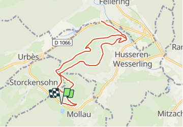

Length
9.9 km

Max alt
708 m

Uphill gradient
475 m
Km-Effort
16.2 km

Min alt
437 m

Downhill gradient
475 m
Boucle
Yes
Creation date :
2018-10-13 05:53:30.355
Updated on :
2018-10-13 05:53:30.363
3h53
Difficulty : Medium

FREE GPS app for hiking
 SityTrail
IGN / Geographical institutes
SityTrail Plus
The world is yours!
About
Trail Walking of 9.9 km to be discovered at Grand Est, Haut-Rhin, Mollau. This trail is proposed by patrickbeyrath.
Description
Très belle marche avec un départ à MOLLAU à hauteur du Ertenweiher, prendre Rond Rouge, direction Seewaldkopf,Huselberg, Pont Rouge et retour, rond rouge par le Chauvelin
Positioning
Country:
France
Region :
Grand Est
Department/Province :
Haut-Rhin
Municipality :
Mollau
Location:
Unknown
Start:(Dec)
Start:(UTM)
348059 ; 5304192 (32T) N.
Comments