Trail Walking Mimizan - De la forêt à l'Océan - Mimizan - Photo

De la forêt à l'Océan - Mimizan

 tracegps
tracegps

User

© OpenStreetMap contributors
Length
Length
51 km
Max alt
Max alt
70 m
Uphill gradient
Uphill gradient
499 m
Km-Effort
Km-Effort  
58 km
Min alt
Min alt
3 m
Downhill gradient
Downhill gradient
497 m
Boucle
Boucle
Yes
Creation date :
2014-12-10 00:00:00.0
Updated on :
2014-12-10 00:00:00.0

(1 Reviews)

Walking
Walking
8h00
Difficulty : Medium

Scan this QR Code to open this trail in the SityTrail application

FREE GPS app for hiking

Logo SityTrail SityTrail

IGN / Geographical institutes

Download SityTrail from the App Store Download SityTrail from Google Play

Logo SityTrail SityTrail World

The world is yours!

Download SityTrail from the App Store Download SityTrail from Google Play Download SityTrail on Huawei AppGallery

About

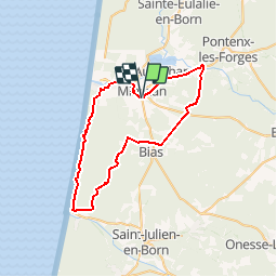
Trail Walking of 51 km to be discovered at New Aquitaine, Landes, Mimizan. This trail is proposed by tracegps.

Description

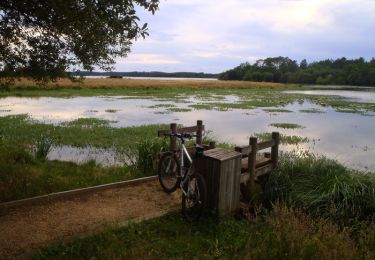
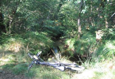
Ce parcours d'une cinquantaine de km permet de découvrir la forêt landaise, le phare de Contis et le littoral de la côte d'argent (entre Contis et Mimizan). N'hésitez pas à mettre pied à terre si le terrain devient trop sablonneux, cela ne dure jamais longtemps. Prévoir une bonne demi journée pour ce circuit (ou une journée entière si vous voulez profiter d'un bain rafraîchissant dans l'Océan).

Elevation profile

Photos

Positioning

Country:
France
Region :
New Aquitaine
Department/Province :
Landes
Municipality :
Mimizan
Location:
Unknown
Start:(UTM)
641321 ; 4895023 (30T) N.

Comments

Please log in to post a review or rate the element


Trails nearby

Trail Walking Aureilhan - Tour du Lac Aureilhan  - Photo
Walking
GUIDE
lhomme.ph

Walking

Difficult
(1)
Aureilhan, New Aquitaine, Landes, France
12.8 km | 14.1 km-effort
2h 24min
Yes
Trail Running Aureilhan - Balade au fil du lac et du courant - Mimizan - Photo
Running
tracegps

Running

Medium
(1)
Aureilhan, New Aquitaine, Landes, France
21 km | 23 km-effort
3h 0min
Yes
Trail On foot Aureilhan - Sentier du Tour du Lac - Photo
On foot
PRO

On foot

Easy
Aureilhan, New Aquitaine, Landes, France
13.6 km | 15.1 km-effort
3h 25min
Yes
Trail Mountain bike Aureilhan - De Mimizan à Biscarrosse - Photo
Mountain bike
tracegps

Mountain bike

Difficult
Aureilhan, New Aquitaine, Landes, France
37 km | 41 km-effort
3h 0min
No
Trail Mountain bike Aureilhan - Balade au fil du lac et du courant - Mimizan - Photo
Mountain bike
tracegps

Mountain bike

Medium
(1)
Aureilhan, New Aquitaine, Landes, France
21 km | 23 km-effort
2h 0min
Yes
Trail Walking Aureilhan - Balade au fil du lac et du courant - Mimizan - Photo
Walking
tracegps

Walking

Difficult
Aureilhan, New Aquitaine, Landes, France
21 km | 23 km-effort
4h 0min
Yes
Trail Running Mimizan - Balade des 5 ponts - Mimizan - Photo
Running
tracegps

Running

Difficult
Mimizan, New Aquitaine, Landes, France
33 km | 37 km-effort
4h 0min
Yes
Trail Mountain bike Mimizan - Balade des 5 ponts - Mimizan - Photo
Mountain bike
tracegps

Mountain bike

Medium
(1)
Mimizan, New Aquitaine, Landes, France
33 km | 37 km-effort
2h 30min
Yes
Trail Walking Mimizan - Balade des 5 ponts - Mimizan - Photo
Walking
tracegps

Walking

Difficult
Mimizan, New Aquitaine, Landes, France
33 km | 37 km-effort
5h 0min
Yes


Close
My subscriptions