Trail Mountain bike Londinières - Circuit de Capval -  Londinières - Photo

Circuit de Capval - Londinières

 tracegps
tracegps

User

© OpenStreetMap contributors
Length
Length
12.2 km
Max alt
Max alt
202 m
Uphill gradient
Uphill gradient
260 m
Km-Effort
Km-Effort  
15.7 km
Min alt
Min alt
63 m
Downhill gradient
Downhill gradient
259 m
Boucle
Boucle
Yes
Creation date :
2014-12-10 00:00:00.0
Updated on :
2014-12-10 00:00:00.0

(0 Reviews)

Mountain bike
Mountain bike
1h15
Difficulty : Medium

Scan this QR Code to open this trail in the SityTrail application

FREE GPS app for hiking

Logo SityTrail SityTrail

IGN / Geographical institutes

Download SityTrail from the App Store Download SityTrail from Google Play

Logo SityTrail SityTrail World

The world is yours!

Download SityTrail from the App Store Download SityTrail from Google Play Download SityTrail on Huawei AppGallery

About

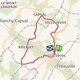
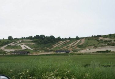
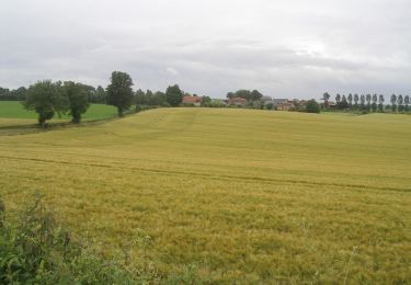
Trail Mountain bike of 12.2 km to be discovered at Normandy, Seine-Maritime, Londinières. This trail is proposed by tracegps.

Description

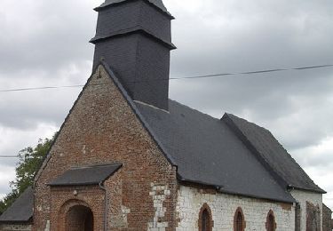
Circuit proposé par le syndicat d'initiative de Londinières. Le départ se fait de l'hôtel de ville de Londinières. Capval signifie « éperon » et pente raide. Au lieu dit, le mont Blanc des fouilles entreprises par l'abbé Cochet et M Cahinght ont mis à jour une nécropole mérovingienne de l'époque franque, de nombreux objets ont été trouvés : vases, lances, épées, boucliers... ils sont conservés au musée Départemental des Antiquités de Rouen. Le circuit passe passe par le Hameau de Boissay, et son château en brique du XVIème siècle, ainsi que devant la chapelle Sainte Mélaine.

Elevation profile

Photos

Positioning

Country:
France
Region :
Normandy
Department/Province :
Seine-Maritime
Municipality :
Londinières
Location:
Unknown
Start:(UTM)
385119 ; 5521251 (31U) N.

Trails nearby

Trail Walking Wanchy-Capval - Circuit de Wanchy - Capval - Photo
Walking
tracegps

Walking

Medium
(1)
Wanchy-Capval, Normandy, Seine-Maritime, France
11.6 km | 13.9 km-effort
2h 55min
Yes
Trail Walking Londinières -  Autour de Londinières - Photo
Walking
tracegps

Walking

Medium
Londinières, Normandy, Seine-Maritime, France
11.8 km | 14.3 km-effort
2h 30min
Yes
Trail Walking Saint-Pierre-des-Jonquières - Circuit de Saint Pierre des Jonquières - Photo
Walking
tracegps

Walking

Medium
Saint-Pierre-des-Jonquières, Normandy, Seine-Maritime, France
12.4 km | 15.1 km-effort
3h 4min
Yes
Trail Walking Londinières - Circuit de Capval -  Londinières - Photo
Walking
tracegps

Walking

Difficult
Londinières, Normandy, Seine-Maritime, France
12.2 km | 15.7 km-effort
3h 10min
Yes
Trail Mountain bike Londinières - Circuit de Londinières - Photo
Mountain bike
tracegps

Mountain bike

Easy
Londinières, Normandy, Seine-Maritime, France
10.9 km | 13.2 km-effort
1h 0min
Yes
Trail Walking Londinières - Circuit de Londinières - Photo
Walking
tracegps

Walking

Medium
Londinières, Normandy, Seine-Maritime, France
10.9 km | 13.2 km-effort
2h 45min
Yes
Trail Walking Bailleul-Neuville - Circuit de Bailleul Neuville - Photo
Walking
tracegps

Walking

Medium
Bailleul-Neuville, Normandy, Seine-Maritime, France
12.1 km | 14.9 km-effort
3h 0min
Yes
Trail Walking Clais - Circuit de Clais - Photo
Walking
tracegps

Walking

Difficult
Clais, Normandy, Seine-Maritime, France
12.5 km | 15.4 km-effort
3h 10min
Yes
Trail Walking Croixdalle - Circuit de Croixdalle - Photo
Walking
tracegps

Walking

Very difficult
Croixdalle, Normandy, Seine-Maritime, France
16.4 km | 21 km-effort
4h 4min
Yes


Close
My subscriptions