Ploumoguer - Lampaul
tracegps
User
Length
48 km
Max alt
141 m
Uphill gradient
610 m
Km-Effort
57 km
Min alt
2 m
Downhill gradient
610 m
Boucle
Yes
Creation date :
2014-12-10 00:00:00.0
Updated on :
2014-12-10 00:00:00.0
3h30
Difficulty : Difficult
FREE GPS app for hiking
About
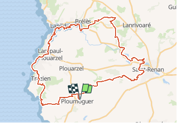
Trail Mountain bike of 48 km to be discovered at Brittany, Finistère, Ploumoguer. This trail is proposed by tracegps.
Description
Départ place de la mairie à Ploumoguer, direction Saint Renan. Passage au château de Kergroadez puis vous longez l'Aber Ildut. Après un "passage technique", un petit tour à Lampaul Plouarzel puis retour à Ploumoguer.
Positioning
Country:
France
Region :
Brittany
Department/Province :
Finistère
Municipality :
Ploumoguer
Location:
Unknown
Start:(Dec)
Start:(UTM)
372832 ; 5362722 (30U) N.
Comments
Trails nearby
Blanc sablons
Walking
(1)
Ploumoguer,
Brittany,
Finistère,
France
15.5 km | 18.9 km-effort
4h 31min
Yes
09.09.23 Lampaul- Plouarzel -- Le Conquet
Walking
Very difficult
Lampaul-Plouarzel,
Brittany,
Finistère,
France
21 km | 26 km-effort
5h 49min
No
au sud du Conquet
Nordic walking
Very easy
Le Conquet,
Brittany,
Finistère,
France
42 km | 50 km-effort
22min
No
Lanpaul - Lochrist
Walking
Medium
Lampaul-Plouarzel,
Brittany,
Finistère,
France
19.8 km | 24 km-effort
5h 7min
No
presqu'île de Kermorvan
Walking
Easy
(2)
Le Conquet,
Brittany,
Finistère,
France
10 km | 11.8 km-effort
2h 54min
Yes
Pointe de Kermovan/Fort de l'Ilette. 22/08/19.
Walking
Easy
Le Conquet,
Brittany,
Finistère,
France
3.9 km | 4.4 km-effort
1h 53min
Yes
Rando de Noël au nord de Brest - Ploumoguer
Mountain bike
Very difficult
Ploumoguer,
Brittany,
Finistère,
France
85 km | 96 km-effort
7h 0min
Yes
73 km autour de Ploumoguer
Mountain bike
Very difficult
Ploumoguer,
Brittany,
Finistère,
France
73 km | 87 km-effort
7h 0min
Yes
De Ploumoguer à la pointe St-Mathieu
Mountain bike
Difficult
Ploumoguer,
Brittany,
Finistère,
France
47 km | 55 km-effort
3h 15min
Yes