Trail Mountain bike Ploumoguer - Carte de France à Ploumoguer - Photo

Carte de France à Ploumoguer

 tracegps
tracegps

User

© OpenStreetMap contributors
Length
Length
55 km
Max alt
Max alt
141 m
Uphill gradient
Uphill gradient
684 m
Km-Effort
Km-Effort  
64 km
Min alt
Min alt
23 m
Downhill gradient
Downhill gradient
684 m
Boucle
Boucle
Yes
Creation date :
2014-12-10 00:00:00.0
Updated on :
2014-12-10 00:00:00.0

(0 Reviews)

Mountain bike
Mountain bike
3h30
Difficulty : Difficult

Scan this QR Code to open this trail in the SityTrail application

FREE GPS app for hiking

Logo SityTrail SityTrail

IGN / Geographical institutes

Download SityTrail from the App Store Download SityTrail from Google Play

Logo SityTrail SityTrail World

The world is yours!

Download SityTrail from the App Store Download SityTrail from Google Play Download SityTrail on Huawei AppGallery

About

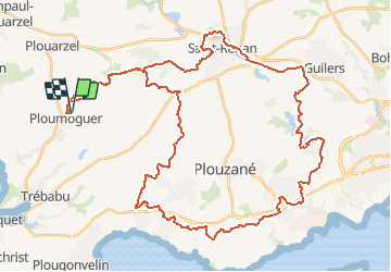
Trail Mountain bike of 55 km to be discovered at Brittany, Finistère, Ploumoguer. This trail is proposed by tracegps.

Description

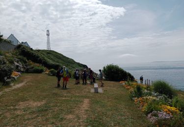
Circuit roulant, la plus grosse difficulté est à la fin. La vue sur le goulet de Brest est très sympathique. Goulet= passage de la haute mer à la rade de Brest.

Elevation profile

Photos

Positioning

Country:
France
Region :
Brittany
Department/Province :
Finistère
Municipality :
Ploumoguer
Location:
Unknown
Start:(UTM)
372833 ; 5362739 (30U) N.

Trails nearby

Trail Walking Ploumoguer - Blanc sablons - Photo
Walking
jybe

Walking

(1)
Ploumoguer, Brittany, Finistère, France
15.5 km | 18.9 km-effort
4h 31min
Yes
Trail Walking Lampaul-Plouarzel - 09.09.23  Lampaul- Plouarzel  -- Le Conquet - Photo
Walking
donda

Walking

Very difficult
Lampaul-Plouarzel, Brittany, Finistère, France
21 km | 26 km-effort
5h 49min
No
Trail Nordic walking Le Conquet - au sud du Conquet - Photo
Nordic walking
elianette

Nordic walking

Very easy
Le Conquet, Brittany, Finistère, France
42 km | 50 km-effort
22min
No
Trail Walking Lampaul-Plouarzel - Lanpaul - Lochrist - Photo
Walking
swp648

Walking

Medium
Lampaul-Plouarzel, Brittany, Finistère, France
19.8 km | 24 km-effort
5h 7min
No
Trail Walking Le Conquet - presqu'île de Kermorvan - Photo
Walking
ahelvig

Walking

Easy
(2)
Le Conquet, Brittany, Finistère, France
10 km | 11.8 km-effort
2h 54min
Yes
Trail Walking Le Conquet - Pointe de Kermovan/Fort de l'Ilette. 22/08/19. - Photo
Walking
Dervalmarc

Walking

Easy
Le Conquet, Brittany, Finistère, France
3.9 km | 4.4 km-effort
1h 53min
Yes
Trail Mountain bike Ploumoguer - Rando de Noël au nord de Brest - Ploumoguer - Photo
Mountain bike
tracegps

Mountain bike

Very difficult
Ploumoguer, Brittany, Finistère, France
85 km | 96 km-effort
7h 0min
Yes
Trail Mountain bike Ploumoguer - 73 km autour de Ploumoguer - Photo
Mountain bike
tracegps

Mountain bike

Very difficult
Ploumoguer, Brittany, Finistère, France
73 km | 87 km-effort
7h 0min
Yes
Trail Mountain bike Ploumoguer - De Ploumoguer à la pointe St-Mathieu - Photo
Mountain bike
tracegps

Mountain bike

Difficult
Ploumoguer, Brittany, Finistère, France
47 km | 55 km-effort
3h 15min
Yes


Close
My subscriptions