Trail Walking Gauchin-Légal - Autour du golf d'Olhain - Gauchin Légal - Photo

Autour du golf d'Olhain - Gauchin Légal

 tracegps
tracegps

User

© OpenStreetMap contributors
Length
Length
8.1 km
Max alt
Max alt
192 m
Uphill gradient
Uphill gradient
156 m
Km-Effort
Km-Effort  
10.2 km
Min alt
Min alt
85 m
Downhill gradient
Downhill gradient
156 m
Boucle
Boucle
Yes
Creation date :
2014-12-10 00:00:00.0
Updated on :
2014-12-10 00:00:00.0

(0 Reviews)

Walking
Walking
2h00
Difficulty : Medium

Scan this QR Code to open this trail in the SityTrail application

FREE GPS app for hiking

Logo SityTrail SityTrail

IGN / Geographical institutes

Download SityTrail from the App Store Download SityTrail from Google Play

Logo SityTrail SityTrail World

The world is yours!

Download SityTrail from the App Store Download SityTrail from Google Play Download SityTrail on Huawei AppGallery

About

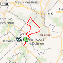
Trail Walking of 8.1 km to be discovered at Hauts-de-France, Pas-de-Calais, Gauchin-Légal. This trail is proposed by tracegps.

Description

Circuit au départ de Gauchin qui fait le tour du golf d'Olhain.

Elevation profile

Photos

Positioning

Country:
France
Region :
Hauts-de-France
Department/Province :
Pas-de-Calais
Municipality :
Gauchin-Légal
Location:
Unknown
Start:(UTM)
470177 ; 5584890 (31U) N.

Trails nearby

Trail On foot Beugin - de Beugin à Bajus - Photo
On foot
Templeuveenmarche

On foot

Easy
(1)
Beugin, Hauts-de-France, Pas-de-Calais, France
10.7 km | 13 km-effort
2h 10min
Yes
Trail Other activity Houdain - Artois tour - Photo
Other activity
cnockaert

Other activity

Very easy
(1)
Houdain, Hauts-de-France, Pas-de-Calais, France
48 km | 59 km-effort
48min
Yes
Trail Walking Béthonsart - Bethonsart Caucourt Mingoval - Photo
Walking
tracegps

Walking

Medium
Béthonsart, Hauts-de-France, Pas-de-Calais, France
11.7 km | 13.2 km-effort
2h 30min
Yes
Trail Walking Houdain - Les Châtaignes d'Houdain - Photo
Walking
tracegps

Walking

Medium
Houdain, Hauts-de-France, Pas-de-Calais, France
7 km | 8.4 km-effort
2h 0min
Yes
Trail Walking Fresnicourt-le-Dolmen - La table aux  fées de Fresnicourt. (Fresnicourt-le-dolmen) - Photo
Walking
tracegps

Walking

Medium
(1)
Fresnicourt-le-Dolmen, Hauts-de-France, Pas-de-Calais, France
11.7 km | 14.3 km-effort
3h 0min
Yes
Trail Walking Villers-Châtel - Chemin de la charbonnière (Villers-Châtel)  - Photo
Walking
tracegps

Walking

Medium
Villers-Châtel, Hauts-de-France, Pas-de-Calais, France
11.8 km | 13.4 km-effort
3h 0min
Yes
Trail Walking Gauchin-Légal - Vieux cailloux et patois - Photo
Walking
tracegps

Walking

Difficult
(2)
Gauchin-Légal, Hauts-de-France, Pas-de-Calais, France
26 km | 31 km-effort
5h 30min
Yes
Trail Walking Cambligneul - Cambigneul - Villers Chatel - Mingoval - Caucourt - Estée Cauchy - Photo
Walking
tracegps

Walking

Medium
Cambligneul, Hauts-de-France, Pas-de-Calais, France
9.9 km | 11.1 km-effort
2h 0min
Yes
Trail Walking Maisnil-lès-Ruitz - Terrils jumeaux des Falandres et du Pays à Part - Photo
Walking
Greg813

Walking

Medium
Maisnil-lès-Ruitz, Hauts-de-France, Pas-de-Calais, France
22 km | 28 km-effort
4h 59min
Yes


Close
My subscriptions