Trail Walking Toulouse - De Toulouse à Bouconne par le GR653 - Photo

De Toulouse à Bouconne par le GR653

 tracegps
tracegps

User

© OpenStreetMap contributors
Length
Length
21 km
Max alt
Max alt
192 m
Uphill gradient
Uphill gradient
187 m
Km-Effort
Km-Effort  
24 km
Min alt
Min alt
121 m
Downhill gradient
Downhill gradient
151 m
Boucle
Boucle
No
Creation date :
2014-12-10 00:00:00.0
Updated on :
2014-12-10 00:00:00.0

(1 Reviews)

Walking
Walking
5h00
Difficulty : Difficult

Scan this QR Code to open this trail in the SityTrail application

FREE GPS app for hiking

Logo SityTrail SityTrail

IGN / Geographical institutes

Download SityTrail from the App Store Download SityTrail from Google Play

Logo SityTrail SityTrail World

The world is yours!

Download SityTrail from the App Store Download SityTrail from Google Play Download SityTrail on Huawei AppGallery

About

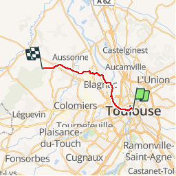
Trail Walking of 21 km to be discovered at Occitania, Haute-Garonne, Toulouse. This trail is proposed by tracegps.

Description

Compostelle - Via Tolosana ou voie d'Arles - GR653. Sortie de Toulouse en évitant les routes à partir de la place du Capitole ou de Saint-Sernin. Elle permet de traverser Blagnac en restant sur des voies naturelles ou chemins protégés (hormis quelques courts passages). Pour les pèlerins, à partir du niveau de Cornebarrieu, reprendre le GR653 direction Pibrac et Léguevin (gîtes).

Elevation profile

Photos

Positioning

Country:
France
Region :
Occitania
Department/Province :
Haute-Garonne
Municipality :
Toulouse
Location:
Unknown
Start:(UTM)
374366 ; 4829179 (31T) N.

Comments

Please log in to post a review or rate the element


Trails nearby

Trail Mountain bike L'Union - Fil Vert VTT du Grand Toulouse - Edition 2008 - 65km - Photo
Mountain bike
tracegps

Mountain bike

Difficult
(1)
L'Union, Occitania, Haute-Garonne, France
66 km | 72 km-effort
4h 30min
Yes
Trail Cycle Toulouse - Canal du Midi - Photo
Cycle
frizou83

Cycle

Very easy
(1)
Toulouse, Occitania, Haute-Garonne, France
259 km | 281 km-effort
15h 55min
No
Trail Walking Toulouse - Tour de Toulouse par la Garonne  - Photo
Walking
CooolGeorges

Walking

Medium
Toulouse, Occitania, Haute-Garonne, France
9.3 km | 11 km-effort
2h 35min
Yes
Trail Walking Toulouse - Toulouse - Pinsaguel  - Photo
Walking
zazibelle

Walking

Easy
(1)
Toulouse, Occitania, Haute-Garonne, France
15.6 km | 17.5 km-effort
4h 59min
No
Trail Walking Blagnac - Blagnac, le long de la Garonne  - Photo
Walking
phil88

Walking

Easy
Blagnac, Occitania, Haute-Garonne, France
5.3 km | 5.9 km-effort
1h 48min
Yes
Trail Cycle Toulouse - Canal du Midi - Etape 1 - Photo
Cycle
frizou83

Cycle

Very easy
Toulouse, Occitania, Haute-Garonne, France
55 km | 61 km-effort
3h 28min
No
Trail Walking Toulouse - Rive Droite Garonne Toulouse Gagnac - Photo
Walking
RR31

Walking

Easy
Toulouse, Occitania, Haute-Garonne, France
24 km | 27 km-effort
5h 55min
No
Trail Walking Toulouse - Rive Droite Garonne Toulouse Gagnac - Photo
Walking
RR31

Walking

Easy
Toulouse, Occitania, Haute-Garonne, France
24 km | 27 km-effort
5h 55min
No
Trail Mountain bike L'Union - Fil Vert VTT du Grand Toulouse - Edition 2008 - 37km - Photo
Mountain bike
tracegps

Mountain bike

Medium
L'Union, Occitania, Haute-Garonne, France
37 km | 40 km-effort
3h 0min
Yes


Close
My subscriptions