Trail Mountain bike Puget - Pied de l'Aigle - Puget - Photo
 tracegps
tracegps

User

© OpenStreetMap contributors
Length
Length
35 km
Max alt
Max alt
721 m
Uphill gradient
Uphill gradient
1209 m
Km-Effort
Km-Effort  
51 km
Min alt
Min alt
151 m
Downhill gradient
Downhill gradient
1209 m
Boucle
Boucle
Yes
Creation date :
2014-12-10 00:00:00.0
Updated on :
2014-12-10 00:00:00.0

(0 Reviews)

Mountain bike
Mountain bike
3h30
Difficulty : Difficult

Scan this QR Code to open this trail in the SityTrail application

FREE GPS app for hiking

Logo SityTrail SityTrail

IGN / Geographical institutes

Download SityTrail from the App Store Download SityTrail from Google Play

Logo SityTrail SityTrail World

The world is yours!

Download SityTrail from the App Store Download SityTrail from Google Play Download SityTrail on Huawei AppGallery

About

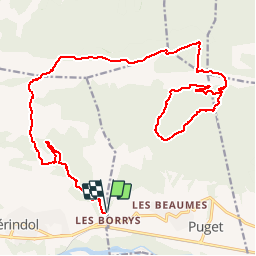
Trail Mountain bike of 35 km to be discovered at Provence-Alpes-Côte d'Azur, Vaucluse, Puget. This trail is proposed by tracegps.

Description

Un très beau circuit au départ des Borrys après Mérindol. 30Kms - 1200 m de   . Première boucle : montée après le DFCI vallon de la tapi jusqu'à l'aire de bosses, ensuite descente technique par le GR, remontée par le même DFCI jusqu'à l'aire de bosses et direction la forêt des cèdres avec du portage, des passages techniques et une belle descente avec pour finir le vallon de la pute et retour au parking des borrys!!!

Elevation profile

Photos

Positioning

Country:
France
Region :
Provence-Alpes-Côte d'Azur
Department/Province :
Vaucluse
Municipality :
Puget
Location:
Unknown
Start:(UTM)
679968 ; 4847511 (31T) N.

Trails nearby

Trail Walking Bonnieux - Forêt de Cêdre - Roque des Bancs - Baume Rousse - Grottes de Font Scure et des Vaudois - Le Portalas  - Photo
Walking
tracegps

Walking

Medium
(5)
Bonnieux, Provence-Alpes-Côte d'Azur, Vaucluse, France
9.3 km | 14.2 km-effort
4h 0min
Yes
Trail On foot Bonnieux - Rando2 foret-des-cedres-bonnieux-2021 - Photo
On foot
ramille

On foot

Medium
(1)
Bonnieux, Provence-Alpes-Côte d'Azur, Vaucluse, France
14.8 km | 24 km-effort
5h 28min
Yes
Trail Walking Charleval - CHAINE DES COTES CHARLEVAL - Photo
Walking
ARPF

Walking

Medium
(1)
Charleval, Provence-Alpes-Côte d'Azur, Bouches-du-Rhône, France
12.6 km | 17.9 km-effort
3h 46min
Yes
Trail Walking Charleval - Gambadous - Charleval - Photo
Walking
Taricot

Walking

Easy
(2)
Charleval, Provence-Alpes-Côte d'Azur, Bouches-du-Rhône, France
7.5 km | 10.5 km-effort
2h 13min
Yes
Trail Walking Mérindol - Mérindol - Photo
Walking
titoune51

Walking

Medium
(1)
Mérindol, Provence-Alpes-Côte d'Azur, Vaucluse, France
7.2 km | 10.2 km-effort
2h 37min
Yes
Trail Walking Mallemort - SityTrail - GRvP - De Mallemort à Mérindol - Photo
Walking
MicDul

Walking

Easy
Mallemort, Provence-Alpes-Côte d'Azur, Bouches-du-Rhône, France
5.3 km | 6.1 km-effort
1h 30min
No
Trail Walking Charleval - Les hauts de Charleval 13 - Photo
Walking
Dadou 1

Walking

Very easy
Charleval, Provence-Alpes-Côte d'Azur, Bouches-du-Rhône, France
9.3 km | 12.3 km-effort
3h 17min
Yes
Trail Walking Puget - SityTrail - Les borries  - Photo
Walking
MicDul

Walking

Medium
Puget, Provence-Alpes-Côte d'Azur, Vaucluse, France
7.5 km | 11 km-effort
3h 0min
Yes
Trail Walking Mérindol - Les Borrys  Tête de la boutique  - Photo
Walking
Manoune

Walking

Easy
Mérindol, Provence-Alpes-Côte d'Azur, Vaucluse, France
13.4 km | 17.9 km-effort
4h 58min
Yes


Close
My subscriptions