


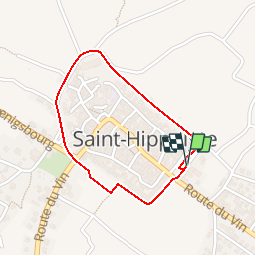
Le tour de St Hippolyte

tracegps
User

Length
1.5 km

Max alt
265 m

Uphill gradient
28 m
Km-Effort
1.9 km

Min alt
231 m

Downhill gradient
30 m
Boucle
Yes
Creation date :
2014-12-10 00:00:00.0
Updated on :
2014-12-10 00:00:00.0
45m
Difficulty : Easy

FREE GPS app for hiking
 SityTrail
IGN / Geographical institutes
SityTrail Plus
The world is yours!
About
Trail Walking of 1.5 km to be discovered at Grand Est, Haut-Rhin, Saint-Hippolyte. This trail is proposed by tracegps.
Description
Une belle rando pour voir un beau petit village du Haut-Rhin et voir de bonne cave. Départ de l'allée des cygnes.
Photos


Positioning
Country:
France
Region :
Grand Est
Department/Province :
Haut-Rhin
Municipality :
Saint-Hippolyte
Location:
Unknown
Start:(Dec)
Start:(UTM)
379081 ; 5343361 (32U) N.
Comments