Trail Walking Éourres - La Montagne de Mare et le Pied du Mulet - Eourres - Photo

La Montagne de Mare et le Pied du Mulet - Eourres

 tracegps
tracegps

User

© OpenStreetMap contributors
Length
Length
14.8 km
Max alt
Max alt
1605 m
Uphill gradient
Uphill gradient
919 m
Km-Effort
Km-Effort  
27 km
Min alt
Min alt
932 m
Downhill gradient
Downhill gradient
919 m
Boucle
Boucle
Yes
Creation date :
2014-12-10 00:00:00.0
Updated on :
2014-12-10 00:00:00.0

(0 Reviews)

Walking
Walking
6h30
Difficulty : Difficult

Scan this QR Code to open this trail in the SityTrail application

FREE GPS app for hiking

Logo SityTrail SityTrail

IGN / Geographical institutes

Download SityTrail from the App Store Download SityTrail from Google Play

Logo SityTrail SityTrail World

The world is yours!

Download SityTrail from the App Store Download SityTrail from Google Play Download SityTrail on Huawei AppGallery

About

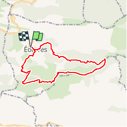
Trail Walking of 14.8 km to be discovered at Provence-Alpes-Côte d'Azur, Hautes-Alpes, Éourres. This trail is proposed by tracegps.

Description

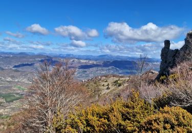
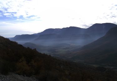
Voila une superbe randonnée, dans les Hautes Alpes, limite de la Drôme, beaux sentier avec environ 5 km de crête vraiment superbe. Arrivé au niveau de la tatie le retour par la droite est certainement plus facile. Retrouvez d'autres photos du circuit.

Elevation profile

Photos

Positioning

Country:
France
Region :
Provence-Alpes-Côte d'Azur
Department/Province :
Hautes-Alpes
Municipality :
Éourres
Location:
Unknown
Start:(UTM)
715394 ; 4899162 (31T) N.

Trails nearby

Trail Walking Saint-Vincent-sur-Jabron - Traversée de la Montagne de Mare depuis Aubard - Photo
Walking
tracegps

Walking

Easy
(1)
Saint-Vincent-sur-Jabron, Provence-Alpes-Côte d'Azur, Alpes-de-Haute-Provence, France
13.3 km | 23 km-effort
5h 45min
Yes
Trail Walking Éourres - mare et pied du mulet - Photo
Walking
y39c43l

Walking

Easy
(1)
Éourres, Provence-Alpes-Côte d'Azur, Hautes-Alpes, France
12.2 km | 23 km-effort
5h 47min
No
Trail Walking Montfroc - 720505 - Photo
Walking
Marco05

Walking

Difficult
Montfroc, Auvergne-Rhône-Alpes, Drôme, France
14.6 km | 26 km-effort
5h 49min
Yes
Trail Walking Saint-Vincent-sur-Jabron - Crête Montagne de Mare - Photo
Walking
PapouBertrand

Walking

Very difficult
Saint-Vincent-sur-Jabron, Provence-Alpes-Côte d'Azur, Alpes-de-Haute-Provence, France
14.8 km | 25 km-effort
5h 44min
Yes
Trail Walking Saint-Vincent-sur-Jabron - SAINT VINCENT DU JABRON.  Aubard,  col de Verdun , le pied du mulet o l m s  - Photo
Walking
RobinMicheline

Walking

Medium
Saint-Vincent-sur-Jabron, Provence-Alpes-Côte d'Azur, Alpes-de-Haute-Provence, France
13.3 km | 23 km-effort
3h 48min
Yes
Trail Walking Éourres - EOURRES.  Les Damias , col S Pierre , col de Branche , crête de Chanteduc , o l m s - Photo
Walking
RobinMicheline

Walking

Easy
Éourres, Provence-Alpes-Côte d'Azur, Hautes-Alpes, France
10 km | 17.9 km-effort
3h 3min
Yes
Trail Walking Saint-Vincent-sur-Jabron - SAINT VINCENT SUR JABRON. Pas de Parandier  ,montagne S Michel o n - Photo
Walking
RobinMicheline

Walking

Medium
Saint-Vincent-sur-Jabron, Provence-Alpes-Côte d'Azur, Alpes-de-Haute-Provence, France
14.4 km | 23 km-effort
4h 13min
Yes
Trail Running Curel - Les Chaux - Curel  - Photo
Running
tracegps

Running

Difficult
Curel, Provence-Alpes-Côte d'Azur, Alpes-de-Haute-Provence, France
8.5 km | 16.2 km-effort
1h 21min
Yes
Trail Walking Curel - Les Chaux - Curel  - Photo
Walking
tracegps

Walking

Medium
Curel, Provence-Alpes-Côte d'Azur, Alpes-de-Haute-Provence, France
8.5 km | 16.2 km-effort
2h 30min
Yes


Close
My subscriptions