Trail Walking Brioude - La Via Arverna (Brioude - Blesle) - Photo

La Via Arverna (Brioude - Blesle)

 tracegps
tracegps

User

© OpenStreetMap contributors
Length
Length
31 km
Max alt
Max alt
613 m
Uphill gradient
Uphill gradient
596 m
Km-Effort
Km-Effort  
39 km
Min alt
Min alt
437 m
Downhill gradient
Downhill gradient
512 m
Boucle
Boucle
No
Creation date :
2014-12-10 00:00:00.0
Updated on :
2014-12-10 00:00:00.0

(0 Reviews)

Walking
Walking
7h00
Difficulty : Difficult

Scan this QR Code to open this trail in the SityTrail application

FREE GPS app for hiking

Logo SityTrail SityTrail

IGN / Geographical institutes

Download SityTrail from the App Store Download SityTrail from Google Play

Logo SityTrail SityTrail World

The world is yours!

Download SityTrail from the App Store Download SityTrail from Google Play Download SityTrail on Huawei AppGallery

About

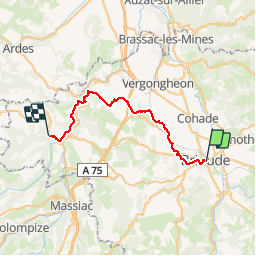
Trail Walking of 31 km to be discovered at Auvergne-Rhône-Alpes, Haute-Loire, Brioude. This trail is proposed by tracegps.

Description

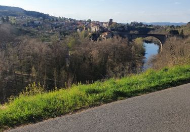
Etape 5 de la Via Arverna, chemin de Saint Jacques de Compostelle entre Clermont-Ferrand et Cahors. Départ de Brioude situé sur les bords de l’Allier pour rejoindre progressivement la vallée et la rivière de l’Allagnon via l’ancien village fortifié de Léotoing. Ensuite, jonction avec la GR41 qui est une GR de Pays « Aux Marche du Cézallier » et passage tranquille pour terminer le parcours. Arrivée à Blesle, classé parmi les plus beaux villages de France. Changement progressif de paysages au cours du chemin et transition en douceur des monts cantaliens. Retrouvez l'étape n° 5 sur le site de la «Via Arverna - chemin Saint-Jacques-de-Compostelle» ainsi qu'ICI sur le site de la « Via Arverna ».

Elevation profile

Photos

Positioning

Country:
France
Region :
Auvergne-Rhône-Alpes
Department/Province :
Haute-Loire
Municipality :
Brioude
Location:
Unknown
Start:(UTM)
530238 ; 5015619 (31T) N.

Trails nearby

Trail Walking Brioude - De Brioude à Vorey en 3 jours - Photo
Walking
tracegps

Walking

Medium
Brioude, Auvergne-Rhône-Alpes, Haute-Loire, France
93 km | 131 km-effort
0h 0min
No
Trail Walking Fontannes - De Fontannes à Lavaudieu - Photo
Walking
tracegps

Walking

Medium
Fontannes, Auvergne-Rhône-Alpes, Haute-Loire, France
15.9 km | 19.9 km-effort
4h 30min
Yes
Trail Mountain bike Brioude - promenade avec canette - Photo
Mountain bike
Yannick Mourlevat

Mountain bike

Very difficult
Brioude, Auvergne-Rhône-Alpes, Haute-Loire, France
49 km | 63 km-effort
3h 49min
Yes
Trail Mountain bike Brioude - Brioude Champagnac - Photo
Mountain bike
tracegps

Mountain bike

Very difficult
Brioude, Auvergne-Rhône-Alpes, Haute-Loire, France
33 km | 44 km-effort
4h 0min
Yes
Trail Walking Brioude - Brioude J 2 - Photo
Walking
MAGZ

Walking

Very difficult
Brioude, Auvergne-Rhône-Alpes, Haute-Loire, France
20 km | 28 km-effort
6h 36min
No
Trail Walking Vieille-Brioude - vieille brioude 3 - Photo
Walking
veroberton

Walking

Medium
Vieille-Brioude, Auvergne-Rhône-Alpes, Haute-Loire, France
13.2 km | 18.5 km-effort
4h 10min
Yes
Trail On foot Lamothe - Lamothe, brioude - Photo
On foot
bernardeau

On foot

Very easy
Lamothe, Auvergne-Rhône-Alpes, Haute-Loire, France
7.4 km | 8.4 km-effort
Unknown
Yes
Trail Walking Vieille-Brioude - vieille-brioude 1 - Photo
Walking
betf

Walking

Medium
(2)
Vieille-Brioude, Auvergne-Rhône-Alpes, Haute-Loire, France
12.5 km | 17.9 km-effort
3h 47min
Yes
Trail Walking Saint-Laurent-Chabreuges - chapelle entremont 43 - Photo
Walking
daniel.wils

Walking

Easy
Saint-Laurent-Chabreuges, Auvergne-Rhône-Alpes, Haute-Loire, France
9.4 km | 12.3 km-effort
2h 41min
Yes


Close
My subscriptions