


OSENBACH-OSENBUHR

patrickbeyrath
User
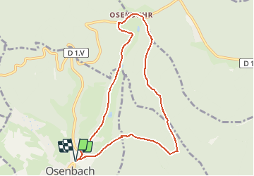

Length
8.4 km

Max alt
588 m

Uphill gradient
247 m
Km-Effort
11.7 km

Min alt
382 m

Downhill gradient
248 m
Boucle
Yes
Creation date :
2018-10-13 05:53:29.922
Updated on :
2018-10-13 05:53:29.931
2h35
Difficulty : Easy

FREE GPS app for hiking
 SityTrail
IGN / Geographical institutes
SityTrail Plus
The world is yours!
About
Trail Walking of 8.4 km to be discovered at Grand Est, Haut-Rhin, Osenbach. This trail is proposed by patrickbeyrath.
Positioning
Country:
France
Region :
Grand Est
Department/Province :
Haut-Rhin
Municipality :
Osenbach
Location:
Unknown
Start:(Dec)
Start:(UTM)
367233 ; 5316400 (32T) N.
Comments