Trail Walking Jouy-en-Josas - Jouy - Bièvres - Igny - Photo

Jouy - Bièvres - Igny

 Tonyar
Tonyar

User

© OpenStreetMap contributors
Length
Length
7 km
Max alt
Max alt
101 m
Uphill gradient
Uphill gradient
48 m
Km-Effort
Km-Effort  
7.7 km
Min alt
Min alt
68 m
Downhill gradient
Downhill gradient
57 m
Boucle
Boucle
No
Creation date :
2014-12-10 00:00:00.0
Updated on :
2014-12-10 00:00:00.0

(1 Reviews)

Walking
Walking
1h10
Difficulty : Unknown

Scan this QR Code to open this trail in the SityTrail application

FREE GPS app for hiking

Logo SityTrail SityTrail

IGN / Geographical institutes

Download SityTrail from the App Store Download SityTrail from Google Play

Logo SityTrail SityTrail World

The world is yours!

Download SityTrail from the App Store Download SityTrail from Google Play Download SityTrail on Huawei AppGallery

About

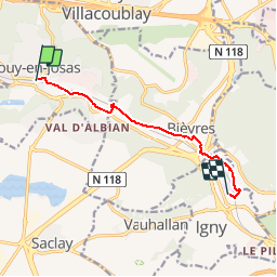
Trail Walking of 7 km to be discovered at Ile-de-France, Yvelines, Jouy-en-Josas. This trail is proposed by Tonyar.

Elevation profile

Positioning

Country:
France
Region :
Ile-de-France
Department/Province :
Yvelines
Municipality :
Jouy-en-Josas
Location:
Unknown
Start:(UTM)
438848 ; 5401617 (31U) N.

Comments

Please log in to post a review or rate the element


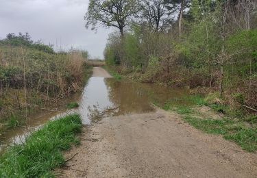
très bien pour une balade en famille. un peu inquiet au début car on suit une route et une voie ferrée, mais ça s'améliore après environ 2 km.


Trails nearby

Trail Walking Chaville - Le Sentier des 7 étangs - Photo
Walking
tracegps

Walking

Difficult
(5)
Chaville, Ile-de-France, Hauts-de-Seine, France
23 km | 31 km-effort
5h 0min
Yes
Trail Walking Bièvres - De Bièvres à Antony - Photo
Walking
tracegps

Walking

Medium
(1)
Bièvres, Ile-de-France, Essonne, France
11.9 km | 14 km-effort
3h 0min
No
Trail Walking Jouy-en-Josas - ferme viltain - Photo
Walking
papoune69

Walking

Very easy
(2)
Jouy-en-Josas, Ile-de-France, Yvelines, France
9 km | 10.1 km-effort
2h 13min
Yes
Trail Walking Viroflay - Les 3 Forêts; Meudon, Fausses Reposes et Versailles - Photo
Walking
tracegps

Walking

Difficult
(2)
Viroflay, Ile-de-France, Yvelines, France
25 km | 32 km-effort
5h 19min
Yes
Trail Walking Chaville - Sentier des deux Forêts - Meudon et Verrières - Photo
Walking
tracegps

Walking

Difficult
(2)
Chaville, Ile-de-France, Hauts-de-Seine, France
23 km | 29 km-effort
5h 0min
Yes
Trail Walking Buc - Le Tour de Satory - Photo
Walking
tracegps

Walking

Difficult
(2)
Buc, Ile-de-France, Yvelines, France
23 km | 28 km-effort
4h 49min
Yes
Trail Walking Bièvres - Autour de Bièvres - Photo
Walking
tracegps

Walking

Medium
(4)
Bièvres, Ile-de-France, Essonne, France
7.6 km | 9.4 km-effort
2h 30min
Yes
Trail Walking Vélizy-Villacoublay - Les forêts de Meudon et Versailles  - Photo
Walking
c.chehere

Walking

Easy
Vélizy-Villacoublay, Ile-de-France, Yvelines, France
14.5 km | 17.2 km-effort
3h 50min
Yes
Trail Walking Guyancourt - Etang de la Geneste - Photo
Walking
mallovon

Walking

Easy
Guyancourt, Ile-de-France, Yvelines, France
3.9 km | 4.9 km-effort
1h 11min
Yes


Close
My subscriptions