


Bergheim Thannenkirch Bergheim

Schnacka
User
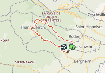

Length
12.2 km

Max alt
560 m

Uphill gradient
358 m
Km-Effort
17 km

Min alt
240 m

Downhill gradient
358 m
Boucle
Yes
Creation date :
2014-12-10 00:00:00.0
Updated on :
2014-12-10 00:00:00.0
3h52
Difficulty : Difficult

FREE GPS app for hiking
 SityTrail
IGN / Geographical institutes
SityTrail Plus
The world is yours!
About
Trail Walking of 12.2 km to be discovered at Grand Est, Haut-Rhin, Bergheim. This trail is proposed by Schnacka.
Description
Superbe promenade qui fait admirer à la fois la plaine d'Alsace, le château du Haut-Koenigsbourg et le village de Thannenkirch.
Positioning
Country:
France
Region :
Grand Est
Department/Province :
Haut-Rhin
Municipality :
Bergheim
Location:
Unknown
Start:(Dec)
Start:(UTM)
377050 ; 5341149 (32U) N.
Comments