Trail Walking Soultzmatt - BANNSTEIN_ORSCHWIHR - Photo

BANNSTEIN_ORSCHWIHR

© OpenStreetMap contributors
Length
Length
10.6 km
Max alt
Max alt
590 m
Uphill gradient
Uphill gradient
382 m
Km-Effort
Km-Effort  
15.7 km
Min alt
Min alt
274 m
Downhill gradient
Downhill gradient
384 m
Boucle
Boucle
Yes
Creation date :
2018-10-13 05:53:29.33
Updated on :
2018-10-13 05:53:29.341

(0 Reviews)

Walking
Walking
3h18
Difficulty : Medium

Scan this QR Code to open this trail in the SityTrail application

FREE GPS app for hiking

Logo SityTrail SityTrail

IGN / Geographical institutes

Download SityTrail from the App Store Download SityTrail from Google Play

Logo SityTrail SityTrail Plus

The world is yours!

Download SityTrail from the App Store Download SityTrail from Google Play Download SityTrail on Huawei AppGallery

About

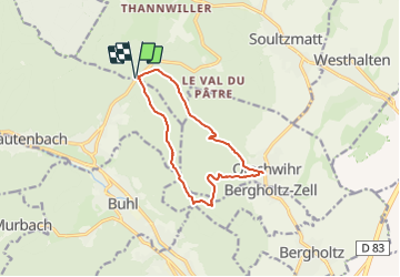
Trail Walking of 10.6 km to be discovered at Grand Est, Haut-Rhin, Soultzmatt. This trail is proposed by patrickbeyrath.

Description

Parking Col du Bannstein, prendre Rond Rouge Col du Dreibannstein-puis circuit vers Orschwihr et repas au Caveau d'Orschwihr et retour Croix Jaunejusqu'au croisement530m et Triangle bleu retour Col de Bannstein

Elevation profile

Positioning

Country:
France
Region :
Grand Est
Department/Province :
Haut-Rhin
Municipality :
Soultzmatt
Location:
Unknown
Start:(UTM)
365057 ; 5312743 (32T) N.


Close
My subscriptions