Trail Cycle Faucon - Entrechaux - Photo
© OpenStreetMap contributors
Length
Length
17.9 km
Max alt
Max alt
339 m
Uphill gradient
Uphill gradient
294 m
Km-Effort
Km-Effort  
22 km
Min alt
Min alt
241 m
Downhill gradient
Downhill gradient
313 m
Boucle
Boucle
No
Creation date :
2014-12-10 00:00:00.0
Updated on :
2014-12-10 00:00:00.0

(0 Reviews)

Cycle
Cycle
1h07
Difficulty : Easy

Scan this QR Code to open this trail in the SityTrail application

FREE GPS app for hiking

Logo SityTrail SityTrail

IGN / Geographical institutes

Download SityTrail from the App Store Download SityTrail from Google Play

Logo SityTrail SityTrail World

The world is yours!

Download SityTrail from the App Store Download SityTrail from Google Play Download SityTrail on Huawei AppGallery

About

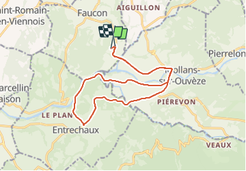
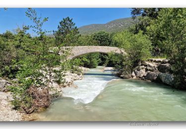
Trail Cycle of 17.9 km to be discovered at Provence-Alpes-Côte d'Azur, Vaucluse, Faucon. This trail is proposed by atuttabirra.

Description

En passant par le Camping Trois Rivières retour par Mollans

Elevation profile

Positioning

Country:
France
Region :
Provence-Alpes-Côte d'Azur
Department/Province :
Vaucluse
Municipality :
Faucon
Location:
Unknown
Start:(UTM)
672041 ; 4901530 (31T) N.

Trails nearby

Trail Walking Entrechaux - Entrechaux en Vaucluse - Photo
Walking
tracegps

Walking

Medium
(1)
Entrechaux, Provence-Alpes-Côte d'Azur, Vaucluse, France
9.5 km | 13.7 km-effort
2h 40min
Yes
Trail On foot Mollans-sur-Ouvèze - Roubion - Photo
On foot
PRO

On foot

Easy
Mollans-sur-Ouvèze, Auvergne-Rhône-Alpes, Drôme, France
4.6 km | 7.3 km-effort
1h 39min
Yes
Trail On foot Mollans-sur-Ouvèze - Pisserouille - Photo
On foot
PRO

On foot

Easy
Mollans-sur-Ouvèze, Auvergne-Rhône-Alpes, Drôme, France
3.5 km | 5.9 km-effort
1h 19min
Yes
Trail On foot Mollans-sur-Ouvèze - Crête et Ubac de Bluye - Photo
On foot
PRO

On foot

Easy
Mollans-sur-Ouvèze, Auvergne-Rhône-Alpes, Drôme, France
7.4 km | 12.8 km-effort
2h 54min
Yes
Trail On foot Mollans-sur-Ouvèze - Adret de Bluye - Photo
On foot
PRO

On foot

Easy
Mollans-sur-Ouvèze, Auvergne-Rhône-Alpes, Drôme, France
9.1 km | 16.6 km-effort
3h 46min
Yes
Trail On foot Mollans-sur-Ouvèze - Mollans - Pierrelongue - Photo
On foot
PRO

On foot

Easy
Mollans-sur-Ouvèze, Auvergne-Rhône-Alpes, Drôme, France
7.5 km | 10.9 km-effort
2h 28min
Yes
Trail Walking Propiac - Propiac(26) - Photo
Walking
jldeval

Walking

Medium
(1)
Propiac, Auvergne-Rhône-Alpes, Drôme, France
14.9 km | 22 km-effort
4h 48min
Yes
Trail Mountain bike Entrechaux - Tour de base VTT - Photo
Mountain bike
oldsars

Mountain bike

Very difficult
(1)
Entrechaux, Provence-Alpes-Côte d'Azur, Vaucluse, France
19.2 km | 28 km-effort
Unknown
Yes
Trail Walking Mollans-sur-Ouvèze - Le Toulourenc  - Photo
Walking
PapouBertrand

Walking

Difficult
Mollans-sur-Ouvèze, Auvergne-Rhône-Alpes, Drôme, France
11.8 km | 17.8 km-effort
4h 2min
Yes


Close
My subscriptions