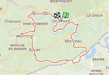
![](/images/other/stat-length.png)
![Trail Walking Stoumont - RB-LG-13 - Par monts et par vaux autour de Stoumont - Photo](https://media.geolcdn.com/t/1900/400/ext.pjpeg?maxdim=2&url=https%3A%2F%2Fservices.sitytrail.com%2FGeolivesWS%2FDownloadMedia.ashx%3FTrailID%3D179571%26Media%3Dfca3b0ca-06fe-45d6-8ded-857ea27270cf.jpg)
RB-LG-13 - Par monts et par vaux autour de Stoumont
GR Rando
Randonnez sur et autour des GR ® wallons (Sentiers de Grande Randonnée). PRO
![Length](/images/other/stat-length.png)
![Max alt](https://static1.geolcdn.com/siteimages/upload/files/1508320355ic_sort_altitude_max_24dp.png)
![Uphill gradient](https://static1.geolcdn.com/siteimages/upload/files/1508320355ic_sort_den_pos_24dp.png)
![Km-Effort](/images/other/stat-length.png)
![Min alt](https://static1.geolcdn.com/siteimages/upload/files/1508320355ic_sort_altitude_min_24dp.png)
![Downhill gradient](https://static1.geolcdn.com/siteimages/upload/files/1508320355ic_sort_den_neg_24dp.png)
![Boucle](https://static1.geolcdn.com/siteimages/upload/files/16400158638029165_repeat_loop_refresh_sync_direction_icon.png)
![Walking](https://static1.geolcdn.com/sitytour/trail-icons/101.png)
7h19
Difficulty : Very difficult
![Scan this QR Code to open this trail in the SityTrail application](https://capi.geolives.com/qq0zvz2zws4bq2lad0pu/sitytour/trails/179571/qr.png?size=200)
FREE GPS app for hiking
About
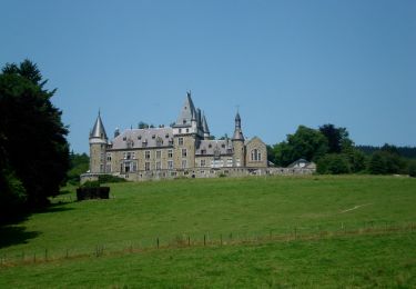
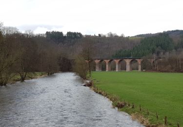
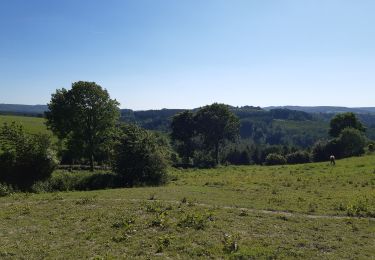
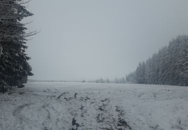
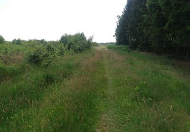
Trail Walking of 23 km to be discovered at Wallonia, Liège, Stoumont. This trail is proposed by GR Rando.
Description
Stoumont – Monceau – Derrière-le-Tige – Rahier – Meuville – Xhierfomont – Targnon – Stoumont
Cartographie et Documentation
Carte IGN au 1 : 20 000, 49/7-8 « Harzé – Stoumont » ou « Carte des Promenades Chevron – Lorcé – Rahier – Stoumont », au 1:25 000,
éditée par le S.I. de Stoumont et réalisée par l’IGN.
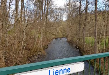
Topo-guide du GR 571 « Vallée des Légendes (Amblève - Salm - Lienne) ».
Où se désaltérer et se restaurer
Un café et un restaurant à Stoumont
Positioning
Comments
Trails nearby
![Trail Walking Trois-Ponts - RB-Lg-27_Trois-Ponts - Photo](https://media.geolcdn.com/t/375/260/ext.jpg?maxdim=2&url=https%3A%2F%2Fservices.sitytrail.com%2FGeolivesWS%2FDownloadMedia.ashx%3FTrailID%3D402090%26Media%3Ddb9e80d9-8efc-4045-abb6-cee4f6885ea2.jpg)
![Walking Walking](https://static1.geolcdn.com/sitytour/trail-icons/101.png)
Walking
![](/images/other/stat-length.png)
![](https://static1.geolcdn.com/siteimages/upload/files/16400158638029165_repeat_loop_refresh_sync_direction_icon.png)
![Trail Walking Stoumont - 2022-02-03_17h52m52_StoumontP14PromenadedessommetsdelaLienne - Photo](https://media.geolcdn.com/t/375/260/ext.jpg?maxdim=2&url=https%3A%2F%2Fmedia.geolcdn.com%2Ff%2Fa2987c7f-4dfa-4904-87e7-be0c835ea8dd.jpg)
![Walking Walking](https://static1.geolcdn.com/sitytour/trail-icons/101.png)
Walking
![](/images/other/stat-length.png)
![](https://static1.geolcdn.com/siteimages/upload/files/16400158638029165_repeat_loop_refresh_sync_direction_icon.png)
![Trail Walking Stoumont - IR-224 & RB-SoirMag-06_La-Glaise-_QR3_Rac1Rac2_13_9_km - Photo](https://media.geolcdn.com/t/375/260/ext.jpg?maxdim=2&url=https%3A%2F%2Fmedia.geolcdn.com%2Ff%2Fc833c403-820e-4132-8cfd-95c8fa336790.JPG)
![Walking Walking](https://static1.geolcdn.com/sitytour/trail-icons/101.png)
Walking
![](/images/other/stat-length.png)
![](https://static1.geolcdn.com/siteimages/upload/files/16400158638029165_repeat_loop_refresh_sync_direction_icon.png)
![Trail Walking Stoumont - 2021-03-12_16h39m43_LaGleizeP3TourduMontSaintVictor - Photo](https://media.geolcdn.com/t/375/260/ext.jpg?maxdim=2&url=https%3A%2F%2Fmedia.geolcdn.com%2Ff%2Feeda461f-0b98-4912-915c-63b0e2025382.jpg)
![Walking Walking](https://static1.geolcdn.com/sitytour/trail-icons/101.png)
Walking
![](/images/other/stat-length.png)
![](https://static1.geolcdn.com/siteimages/upload/files/16400158638029165_repeat_loop_refresh_sync_direction_icon.png)
![Trail Walking Trois-Ponts - RB-Lg-27_Trois-Ponts_via-racc - Photo](https://media.geolcdn.com/t/375/260/ext.jpg?maxdim=2&url=https%3A%2F%2Fservices.sitytrail.com%2FGeolivesWS%2FDownloadMedia.ashx%3FTrailID%3D402091%26Media%3Ddb9e80d9-8efc-4045-abb6-cee4f6885ea2.jpg)
![Walking Walking](https://static1.geolcdn.com/sitytour/trail-icons/101.png)
Walking
![](/images/other/stat-length.png)
![](https://static1.geolcdn.com/siteimages/upload/files/16400158638029165_repeat_loop_refresh_sync_direction_icon.png)
![Trail Walking Stoumont - stoumont . corniche - congo . chateau froidcourt . ambleve . stoumont - Photo](https://media.geolcdn.com/t/375/260/ext.jpg?maxdim=2&url=https%3A%2F%2Fmedia.geolcdn.com%2Ff%2Fe9a69a2e-c189-4076-b755-49e5203b8455.jpg)
![Walking Walking](https://static1.geolcdn.com/sitytour/trail-icons/101.png)
Walking
![](/images/other/stat-length.png)
![](https://static1.geolcdn.com/siteimages/upload/files/16400158638029165_repeat_loop_refresh_sync_direction_icon.png)
![Trail Walking Theux - petit tour à Bronromme - Photo](https://media.geolcdn.com/t/375/260/ext.jpg?maxdim=2&url=https%3A%2F%2Fmedia.geolcdn.com%2Ff%2F3bde52fd-19d7-4e01-be15-97a6eaa8c76d.jpg)
![Walking Walking](https://static1.geolcdn.com/sitytour/trail-icons/101.png)
Walking
![](/images/other/stat-length.png)
![](https://static1.geolcdn.com/siteimages/upload/files/16400158638029165_repeat_loop_refresh_sync_direction_icon.png)
![Trail Walking Stoumont - RB-Lg-13-BC-2019_Rac - Photo](https://media.geolcdn.com/t/375/260/ext.jpg?maxdim=2&url=https%3A%2F%2Fservices.sitytrail.com%2FGeolivesWS%2FDownloadMedia.ashx%3FTrailID%3D179572%26Media%3Ddd649bf1-a115-4c1e-9e23-c1a80ab51103.jpg)
![Walking Walking](https://static1.geolcdn.com/sitytour/trail-icons/101.png)
Walking
![](/images/other/stat-length.png)
![](https://static1.geolcdn.com/siteimages/upload/files/16400158638029165_repeat_loop_refresh_sync_direction_icon.png)
![Trail Walking Theux - bronrome . monthouet . chefna . bronrome - Photo](https://media.geolcdn.com/t/375/260/ext.jpg?maxdim=2&url=https%3A%2F%2Fmedia.geolcdn.com%2Ff%2F5a316177-182e-4883-886e-9003cc3351cb.jpg)
![Walking Walking](https://static1.geolcdn.com/sitytour/trail-icons/101.png)
Walking
![](/images/other/stat-length.png)
![](https://static1.geolcdn.com/siteimages/upload/files/16400158638029165_repeat_loop_refresh_sync_direction_icon.png)
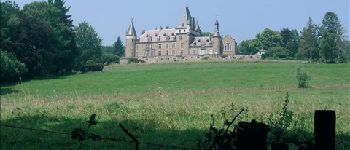
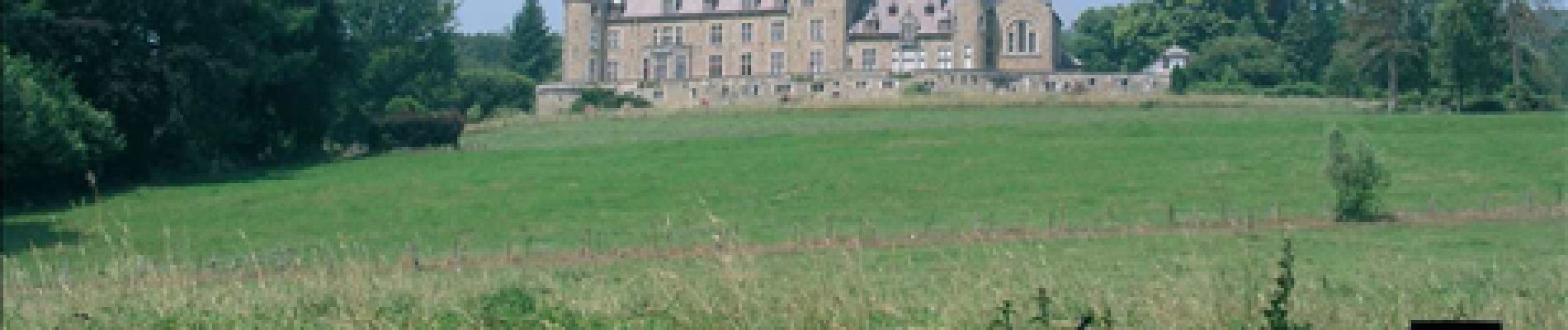
Très belle randonnée, alternant forêts, villages, clairières, cours d'eau, quelques champs et un petit tronçon de poésie à découvrir. On découvre les deux versants de la vallée, dans un environnement calme.
Promenade vari?e, belles vues et touches de po?sie.
Super rando, terrain difficile et varié, seul avec la nature et un magnifique point de vue au niveau de Meuville :)
Très belle rando chemins de tout type et bien seul avec la nature . Assez difficile tout de même et un magnifique point de vue à meuville :)