Trail Walking Yvoir - RB-Na-03 Forteresses, citadelle et abbaye mosanes - Photo

RB-Na-03 Forteresses, citadelle et abbaye mosanes

Randonnez sur et autour des GR ® wallons (Sentiers de Grande Randonnée). PRO

© OpenStreetMap contributors
Length
Length
22 km
Max alt
Max alt
260 m
Uphill gradient
Uphill gradient
638 m
Km-Effort
Km-Effort  
30 km
Min alt
Min alt
86 m
Downhill gradient
Downhill gradient
635 m
Boucle
Boucle
Yes
Creation date :
2019-08-07 07:27:10.535
Updated on :
2021-07-05 07:29:46.729

(10 Reviews)

Walking
Walking
7h01
Difficulty : Difficult

Scan this QR Code to open this trail in the SityTrail application

FREE GPS app for hiking

Logo SityTrail SityTrail

IGN / Geographical institutes

Download SityTrail from the App Store Download SityTrail from Google Play

Logo SityTrail SityTrail World

The world is yours!

Download SityTrail from the App Store Download SityTrail from Google Play Download SityTrail on Huawei AppGallery

About

Trail Walking of 22 km to be discovered at Wallonia, Namur, Yvoir. This trail is proposed by GR Rando.

Description

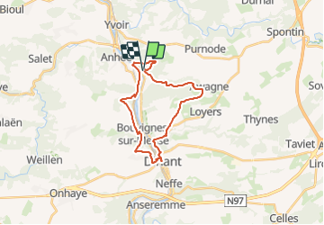
Houx – Dinant – Bouvignes – Houx
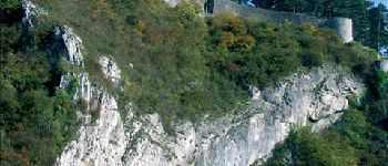
Cet itinéraire se révèle à la fois panoramique et culturel. Entre Dinant et Namur, en effet, la Meuse est bordée de hautes collines. Depuis le Moyen Âge, ces pitons rocheux ont accueilli des forteresses, dont le randonneur côtoiera les vestiges ou les aménagements ultérieurs. Ces éminences constituent aussi autant de belvédères naturels qu’il faut mériter à la force du jarret. Au fond de la vallée mosane, Dinant, Bouvignes et Leffe recèlent encore des monuments  architecturaux, religieux et civils, témoins de leur opulence passée.

Cartographie et documentation:
Cartes IGN au 1 : 20 000, 53/3-4 « Anhée – Yvoir » et 53/7-8 « Hastière – Dinant ».

Carte « Promenades de Dinant et de ses anciennes communes » au 1 : 25 000, éditée par le Syndicat d’Initiative de Dinant en collaboration avec l’IGN.

Carte « Promenades d’Anhée » au 1 : 25 000, éditée par le Syndicat d’Initiative d’Anhée en collaboration avec l’IGN.

Topo-guides des GR 125 « Tour de l’Entre-Sambre-et-Meuse », GR 126 « Bruxelles – Namur – Membre-sur-Semois », GR 129 « La Belgique en diagonale, tronçon Ellezelles – Mons – Dinant ».

Où se désaltérer et se restaurer :
À Leffe, bistrot à deux pas de l’abbaye. Sur le site de la citadelle de Dinant, 50 mètres à droite à l’écart du GR, la taverne voisine du cimetière militaire est accueillante pour les randonneurs.
À Dinant, bien sûr, cafés, restaurants et hôtels. Le randonneur qui désire y faire halte aura intérêt à passer le pont : le quartier de la gare évite un tant soit peu la foule touristique du bord de Meuse. En fin de parcours, l’auberge de Bouvignes, très accueillante, pratique des prix très démocratiques.

Photos

Points of interest

Point of interest Dinant - Chêne remarquable - Photo
GR Rando
Point of interest Dinant - Abbaye de Leffe - Photo
GR Rando
Point of interest Dinant - Citadelle de Dinant - Photo
GR Rando
Point of interest Dinant - Parc de Mont-Fat - Photo
GR Rando
Point of interest Dinant - Dinant - Photo
GR Rando
DINANT 
Point of interest Dinant - Bouvignes - Photo
GR Rando
DINANT 
Point of interest Anhée - Ecluse de Houx - Photo
GR Rando
Point of interest Yvoir - Ruines de Poilvache - Photo
GR Rando
Point of interest Dinant - Chapelle de Bonsecours - Photo
GR Rando

Positioning

Country:
Belgium
Region :
Wallonia
Department/Province :
Namur
Municipality :
Yvoir
Location:
Unknown
Start:(UTM)
635219 ; 5574054 (31U) N.

Comments

Please log in to post a review or rate the element


magnifique


Les 7-8 premiers kilomètres ne sont pas vraiment agréable mais une fois arrivé à Dinant c est du pure bonheur !


Très belle région, une pause le long de la Meuse à Dinant était fort appréciable. Cependant, dommage que la végétation cache bien souvent la vue panoramique que l'on pourrait avoir, mais c'est une rando à faire malgré tout.


Trails nearby

Trail Walking Anhée - RF-Na-05 Annevoie, côté Jardins_Grande-boucle - Photo
Walking
PRO

Walking

Medium
(11)
Anhée, Wallonia, Namur, Belgium
11.3 km | 14.5 km-effort
3h 6min
Yes
Trail Walking Anhée - RF-Na-05 Annevoie, côté Jardins_Petite-boucle - Photo
Walking
PRO

Walking

Easy
(7)
Anhée, Wallonia, Namur, Belgium
7.4 km | 10 km-effort
2h 7min
Yes
Trail Walking Onhaye - RB-Na-C2-Sommière-Complet_20,4km - Photo
Walking
PRO

Walking

Very difficult
(2)
Onhaye, Wallonia, Namur, Belgium
20 km | 25 km-effort
5h 25min
Yes
Trail Walking Dinant - Balade à Dinant - La Réserve Naturelle de Moniat - Photo
Walking
GUIDE
Desrumaux

Walking

Very easy
(1)
Dinant, Wallonia, Namur, Belgium
8.4 km | 10.9 km-effort
3h 54min
Yes
Trail Walking Yvoir - D'Yvoir à Evrehailles - Photo
Walking
GUIDE
Desrumaux

Walking

Easy
(2)
Yvoir, Wallonia, Namur, Belgium
9.9 km | 13.2 km-effort
2h 51min
Yes
Trail Walking Dinant - Balade à Bouvignes - Photo
Walking
GUIDE
Desrumaux

Walking

Easy
(3)
Dinant, Wallonia, Namur, Belgium
4.8 km | 7.2 km-effort
1h 34min
Yes
Trail Walking Dinant - Balade en Réserve Naturelle de Devant Bouvignes - Photo
Walking
GUIDE
Desrumaux

Walking

Very easy
(3)
Dinant, Wallonia, Namur, Belgium
4.9 km | 6.9 km-effort
1h 32min
Yes
Trail Walking Anhée - D''Annevoie à Godinne par les Rochers de Finevoie - Photo
Walking
GUIDE
Desrumaux

Walking

Medium
(3)
Anhée, Wallonia, Namur, Belgium
9.7 km | 13.6 km-effort
2h 57min
Yes
Trail Walking Yvoir - Le long du Bocq Yvoir  - Photo
Walking
BordercollieM_O

Walking

Very easy
(6)
Yvoir, Wallonia, Namur, Belgium
6.9 km | 9.2 km-effort
1h 37min
Yes


Close
My subscriptions