Trail Winter sports Bulle - Bulle - Gîte d''Allières - Photo

Bulle - Gîte d''Allières

© OpenStreetMap contributors
Length
Length
42 km
Max alt
Max alt
1495 m
Uphill gradient
Uphill gradient
1417 m
Km-Effort
Km-Effort  
61 km
Min alt
Min alt
674 m
Downhill gradient
Downhill gradient
1417 m
Boucle
Boucle
Yes
Creation date :
2014-12-11 00:00:00.0
Updated on :
2014-12-11 00:00:00.0

(0 Reviews)

Winter sports
Winter sports
--
Difficulty : Unknown

Scan this QR Code to open this trail in the SityTrail application

FREE GPS app for hiking

Logo SityTrail SityTrail

IGN / Geographical institutes

Download SityTrail from the App Store Download SityTrail from Google Play

Logo SityTrail SityTrail World

The world is yours!

Download SityTrail from the App Store Download SityTrail from Google Play Download SityTrail on Huawei AppGallery

About

Trail Winter sports of 42 km to be discovered at Fribourg, Gruyère District, Bulle. This trail is proposed by vttnature.

Description

Course sympathique, très exposée au soleil.
Topo : Après avoir traversé le bois de Bouleyres jusqu''à Broc, rejoindre Charmey via le Motélon (indicateur à la sortie de Broc). Rejoindre le centre du village de Charmey et suivre Les Sciernes (de suite après de café de l''Etoile à droite). Peux après la cote 990, aux environs du Km 17, prendre à gauche pour rejoindre le couvent de la Valsainte. La traversée du Javroz passe par un très joli pont en bois. 100m apès le Valsainte, prendre à gauche en direction de la Gîte d''Allières. Depuis la Gîte d''Allières, descendre à pleine pente vers le sud-ouest jusqu''à la route goudronnée. Prendre cette route à la descente, à gauche. Poursuivre via Au Solitou jusqu''au dernier chalet, la Chia. Descendre dans le pâtuage jusqu''au chalet la Guille. Poursuivre jusqu''au chalet Bimont. Portage le long de la forêt jusqu''a la route alpestre (environ 600m). Descendre la route jusqu''à la cote 906 et prendre le chemin à gauche. Rejoignez Villarvollard, Broc fabrique et enfin Bulle.

Elevation profile

Positioning

Country:
Switzerland
Region :
Fribourg
Department/Province :
Gruyère District
Municipality :
Bulle
Location:
Unknown
Start:(UTM)
351972 ; 5164184 (32T) N.

Trails nearby

Trail Walking Bulle - Broc FR - Notre Dame des Marches - Photo
Walking
furggstalden

Walking

Very easy
(1)
Bulle, Fribourg, Gruyère District, Switzerland
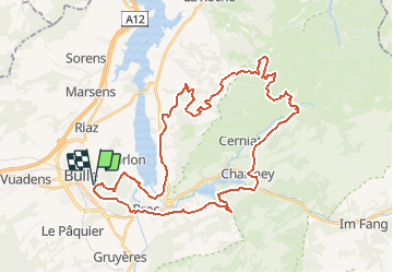
14.3 km | 19.7 km-effort
4h 37min
Yes
Trail On foot Gruyères - Sentier des Pauvres - Photo
On foot
PRO

On foot

Easy
Gruyères, Fribourg, Gruyère District, Switzerland
5.9 km | 8.5 km-effort
1h 55min
No
Trail Cycle Gruyères - st_ral_5 - Photo
Cycle
GUIDE+

Cycle

Very easy
Gruyères, Fribourg, Gruyère District, Switzerland
34 km | 55 km-effort
Unknown
No
Trail Walking Marsens - st_bg_villars2 - Photo
Walking
GUIDE+

Walking

Very easy
Marsens, Fribourg, Gruyère District, Switzerland
136 km | 206 km-effort
Unknown
No
Trail Walking Broc - Gorges de la Jogne, lac de Montsalvens circuit 07.04.17 - Photo
Walking
duamerg

Walking

Medium
Broc, Fribourg, Gruyère District, Switzerland
12.6 km | 19 km-effort
4h 17min
Yes
Trail Walking Bulle - Bulle-Le Vissieu-Bulle - Photo
Walking

Walking

Easy
Bulle, Fribourg, Gruyère District, Switzerland
6.5 km | 8.7 km-effort
2h 14min
Yes
Trail Walking Corbières - Corbières-Impart-Le Ruz-Hauteville - Photo
Walking
rene.esseiva

Walking

Medium
Corbières, Fribourg, Gruyère District, Switzerland
7.8 km | 10.8 km-effort
2h 27min
Yes
Trail Walking Bulle - Bulle-Le Vissieu-Bulle - Photo
Walking
rene.esseiva

Walking

Easy
Bulle, Fribourg, Gruyère District, Switzerland
6.5 km | 8.7 km-effort
2h 14min
Yes
Trail Walking Bulle - Bulle - Le Vessieu - Bois de Bouleyres - Photo
Walking
gpiller

Walking

Very easy
Bulle, Fribourg, Gruyère District, Switzerland
6.8 km | 8.9 km-effort
2h 0min
Yes


Close
My subscriptions