Trail Winter sports Bulle - Bulle - Gros-Plané - Photo
© OpenStreetMap contributors
Length
Length
26 km
Max alt
Max alt
1503 m
Uphill gradient
Uphill gradient
878 m
Km-Effort
Km-Effort  
38 km
Min alt
Min alt
780 m
Downhill gradient
Downhill gradient
882 m
Boucle
Boucle
Yes
Creation date :
2014-12-11 00:00:00.0
Updated on :
2014-12-11 00:00:00.0

(0 Reviews)

Winter sports
Winter sports
--
Difficulty : Unknown

Scan this QR Code to open this trail in the SityTrail application

FREE GPS app for hiking

Logo SityTrail SityTrail

IGN / Geographical institutes

Download SityTrail from the App Store Download SityTrail from Google Play

Logo SityTrail SityTrail World

The world is yours!

Download SityTrail from the App Store Download SityTrail from Google Play Download SityTrail on Huawei AppGallery

About

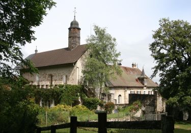
Trail Winter sports of 26 km to be discovered at Fribourg, Gruyère District, Bulle. This trail is proposed by vttnature.

Description

Longueur : 25 Km
Dénivelée positive : 900 m
Altitude de départ : 777 m
Altitude maximale : 1489 m

Course ombragée, sans difficultée particulière.

Topo : Du parc d''Espace Gruyère, suivre la rue de Vevey en direction de la Chia. A 1,5 Km, à la hauteur d''un hangar de l''armée, prendre à droite puis à gauche en direction des Citards. Suivre la route sur toute la longueur de la vallée de la Trême. Après le chalet la Raisse, passage du ruisseau par un gué. Continuer sur 700m et prendre à gauche. Suivre la route jusqu''au chalet Le Village Nègre, à la cote 1407. Prendre à gauche un chemin en direction du chalet Villard-dessous. Suivre le chemin jusqu''à Gros-Plané. Prendre le chemin à droite vers Petit-Plané. Peu à près le chalet, prendre le sentier qui descend vers les Clés. Avant la chapelle des Clés, prendre à droite vers le chalet de la Rupa. Suivre la route sur 2''300m environ et prendre à gauche. Suivre le sentier (peu marqué) à travers le pâturage. Suivre ensuite le chemin jusqu''au pont du Moulin de la Trême. Prendre à droite et suivre le sentier. Au milieu de la petite forêt, prendre à gauche et traverser la Trême sur la passerelle. Rejoindre Espace Gruyère.

Elevation profile

Positioning

Country:
Switzerland
Region :
Fribourg
Department/Province :
Gruyère District
Municipality :
Bulle
Location:
Unknown
Start:(UTM)
350589 ; 5164183 (32T) N.

Trails nearby

Trail Walking Bulle - Broc FR - Notre Dame des Marches - Photo
Walking
furggstalden

Walking

Very easy
(1)
Bulle, Fribourg, Gruyère District, Switzerland
14.3 km | 19.7 km-effort
4h 37min
Yes
Trail On foot Gruyères - Sentier des Pauvres - Photo
On foot
PRO

On foot

Easy
Gruyères, Fribourg, Gruyère District, Switzerland
5.9 km | 8.5 km-effort
1h 55min
No
Trail Cycle Gruyères - st_ral_5 - Photo
Cycle
GUIDE+

Cycle

Very easy
Gruyères, Fribourg, Gruyère District, Switzerland
34 km | 55 km-effort
Unknown
No
Trail Walking Marsens - st_bg_villars2 - Photo
Walking
GUIDE+

Walking

Very easy
Marsens, Fribourg, Gruyère District, Switzerland
136 km | 206 km-effort
Unknown
No
Trail Walking Broc - Gorges de la Jogne, lac de Montsalvens circuit 07.04.17 - Photo
Walking
duamerg

Walking

Medium
Broc, Fribourg, Gruyère District, Switzerland
12.6 km | 19 km-effort
4h 17min
Yes
Trail Walking Bulle - Bulle-Le Vissieu-Bulle - Photo
Walking

Walking

Easy
Bulle, Fribourg, Gruyère District, Switzerland
6.5 km | 8.7 km-effort
2h 14min
Yes
Trail Walking Corbières - Corbières-Impart-Le Ruz-Hauteville - Photo
Walking
rene.esseiva

Walking

Medium
Corbières, Fribourg, Gruyère District, Switzerland
7.8 km | 10.8 km-effort
2h 27min
Yes
Trail Walking Bulle - Bulle-Le Vissieu-Bulle - Photo
Walking
rene.esseiva

Walking

Easy
Bulle, Fribourg, Gruyère District, Switzerland
6.5 km | 8.7 km-effort
2h 14min
Yes
Trail Walking Bulle - Bulle - Le Vessieu - Bois de Bouleyres - Photo
Walking
gpiller

Walking

Very easy
Bulle, Fribourg, Gruyère District, Switzerland
6.8 km | 8.9 km-effort
2h 0min
Yes


Close
My subscriptions