Trail Walking Pinel-Hauterive - Rando ASPTT du 2013/04/04 _ Saint-Pierre de Caubel (47380) - Photo

Rando ASPTT du 2013/04/04 _ Saint-Pierre de Caubel (47380)

 Elbe
Elbe

User

© OpenStreetMap contributors
Length
Length
12.3 km
Max alt
Max alt
208 m
Uphill gradient
Uphill gradient
252 m
Km-Effort
Km-Effort  
15.7 km
Min alt
Min alt
77 m
Downhill gradient
Downhill gradient
253 m
Boucle
Boucle
Yes
Creation date :
2014-12-10 00:00:00.0
Updated on :
2014-12-10 00:00:00.0

(0 Reviews)

Walking
Walking
3h22
Difficulty : Medium

Scan this QR Code to open this trail in the SityTrail application

FREE GPS app for hiking

Logo SityTrail SityTrail

IGN / Geographical institutes

Download SityTrail from the App Store Download SityTrail from Google Play

Logo SityTrail SityTrail World

The world is yours!

Download SityTrail from the App Store Download SityTrail from Google Play Download SityTrail on Huawei AppGallery

About

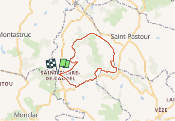
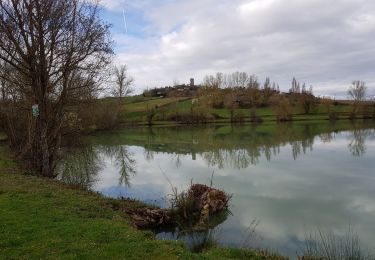
Trail Walking of 12.3 km to be discovered at New Aquitaine, Lot-et-Garonne, Pinel-Hauterive. This trail is proposed by Elbe.

Description

Départ du parking de l'église de Saint-Pierre de Caubel vers Caussade, Roche Haut, Auzac, Latapie, puis retour à l'église.

Elevation profile

Positioning

Country:
France
Region :
New Aquitaine
Department/Province :
Lot-et-Garonne
Municipality :
Pinel-Hauterive
Location:
Unknown
Start:(UTM)
305026 ; 4926806 (31T) N.

Trails nearby

Trail Nordic walking Monclar - Monclar M N 17 11 2019 - Photo
Nordic walking
Forsans

Nordic walking

Easy
Monclar, New Aquitaine, Lot-et-Garonne, France
10.2 km | 12.5 km-effort
1h 58min
Yes
Trail Walking Monclar - ASPTT du 2014-03-11 Monclar - Photo
Walking
Elbe

Walking

Medium
Monclar, New Aquitaine, Lot-et-Garonne, France
11.3 km | 13.8 km-effort
2h 59min
Yes
Trail Walking Saint-Pastour - Saint Pastour - Photo
Walking
christiane01

Walking

Medium
Saint-Pastour, New Aquitaine, Lot-et-Garonne, France
6.5 km | 8.2 km-effort
2h 13min
Yes
Trail Walking Monclar - Montclar - Photo
Walking
christiane01

Walking

Medium
Monclar, New Aquitaine, Lot-et-Garonne, France
7.2 km | 9 km-effort
2h 18min
Yes
Trail Walking Saint-Pastour - St Pastour-Casseneuil - Photo
Walking
Veberpascal

Walking

Medium
Saint-Pastour, New Aquitaine, Lot-et-Garonne, France
12.2 km | 15.2 km-effort
2h 30min
Yes
Trail sport Pinel-Hauterive - 2023-04-10_13h33m26_Trace-356-SaintPierredeCaubel-2022 - Photo
sport
Francinedu

sport

Very easy
Pinel-Hauterive, New Aquitaine, Lot-et-Garonne, France
12.2 km | 15.6 km-effort
Unknown
Yes
Trail Walking Saint-Pastour - Saint Pastour - Photo
Walking
Francinedu

Walking

Difficult
Saint-Pastour, New Aquitaine, Lot-et-Garonne, France
12.5 km | 16.6 km-effort
3h 46min
Yes
Trail Walking Saint-Pastour - 2011-11-07 10h50m17 - Photo
Walking
Veberpascal

Walking

Easy
Saint-Pastour, New Aquitaine, Lot-et-Garonne, France
4.6 km | 5.8 km-effort
1h 1min
Yes


Close
My subscriptions