Trail Other activity Savièse - Le Valais par l''Adret - Etape 4/6 - Photo

Le Valais par l''Adret - Etape 4/6

 Romrando
Romrando

User

© OpenStreetMap contributors
Length
Length
13 km
Max alt
Max alt
2887 m
Uphill gradient
Uphill gradient
845 m
Km-Effort
Km-Effort  
24 km
Min alt
Min alt
2241 m
Downhill gradient
Downhill gradient
891 m
Boucle
Boucle
No
Creation date :
2014-12-11 00:00:00.0
Updated on :
2014-12-11 00:00:00.0

(0 Reviews)

Other activity
Other activity
--
Difficulty : Unknown

Scan this QR Code to open this trail in the SityTrail application

FREE GPS app for hiking

Logo SityTrail SityTrail

IGN / Geographical institutes

Download SityTrail from the App Store Download SityTrail from Google Play

Logo SityTrail SityTrail World

The world is yours!

Download SityTrail from the App Store Download SityTrail from Google Play Download SityTrail on Huawei AppGallery

About

Trail Other activity of 13 km to be discovered at Valais/Wallis, Sion, Savièse. This trail is proposed by Romrando.

Description

Source:geocities.com/romrando

Etape 4 - Cabane Prarochet - Cabane des Audannes (2''508 m)

De la cabane partir vers le NNE par les lapiaz en direction du col du Sanestch.

Suivre alors par une raide montée la très fine et belle arête de l''Arpille jusqu''à une épaule un peu au-dessus du point 2''652 m. Une traversée légèrement descendante dans des pierriers mène au vallon des Grandes Gouilles.

On rejoint le lac (P. 2''471 m) puis après avoir franchit le torrent, on entame l''ascension d''un raide et vaste pierrier qui mène vers des rochers verticaux. Le chemin assez confortable met le cap sur l''E jusqu''à atteindre un petit collet. Une courte traversée exposée à droite mène vers une corde que l''on remonte dans un terrain très raide. On aboutit alors sur une échelle qui vous dépose au col des Audannes (2''886 m ).

De là on atteint facilement la Selle puis la cabane des Audannes.

Elevation profile

Positioning

Country:
Switzerland
Region :
Valais/Wallis
Department/Province :
Sion
Municipality :
Savièse
Location:
Unknown
Start:(UTM)
365067 ; 5130478 (32T) N.

Trails nearby

Trail Nordic walking Savièse - 25.08.20 Sanetsch - Photo
Nordic walking
suzanne.bron

Nordic walking

Very easy
Savièse, Valais/Wallis, Sion, Switzerland
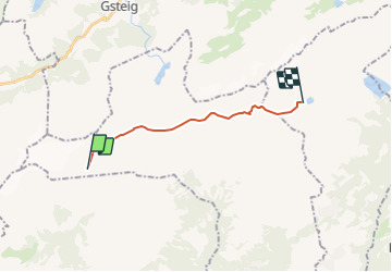
13.3 km | 20 km-effort
5h 32min
No
Trail Walking Savièse - st_bg_antannes - Photo
Walking
GUIDE+

Walking

Very easy
Savièse, Valais/Wallis, Sion, Switzerland
8.9 km | 19.1 km-effort
Unknown
No
Trail Walking Ormont-Dessus - Glacier3000 - Sanetsch - Photo
Walking
GUIDE+

Walking

Very easy
Ormont-Dessus, Vaud, District d'Aigle, Switzerland
19.8 km | 43 km-effort
Unknown
No
Trail Walking Savièse - st_koreatv08_07 - Photo
Walking
GUIDE+

Walking

Very easy
Savièse, Valais/Wallis, Sion, Switzerland
4.5 km | 8.9 km-effort
1h 37min
No
Trail Walking Conthey - huetten_02 - Photo
Walking
GUIDE+

Walking

Very easy
Conthey, Valais/Wallis, Conthey, Switzerland
50 km | 102 km-effort
16h 52min
Yes
Trail Walking Ormont-Dessus - w10_24_diable - Photo
Walking
GUIDE+

Walking

Very easy
Ormont-Dessus, Vaud, District d'Aigle, Switzerland
12.9 km | 17.3 km-effort
3h 38min
No
Trail Walking Conthey - Trajet du 29.10.21 - Photo
Walking
Leemans

Walking

Very difficult
Conthey, Valais/Wallis, Conthey, Switzerland
19.5 km | 38 km-effort
8h 42min
Yes
Trail Walking Conthey - Lac Forcla - Photo
Walking
jipi2

Walking

Medium
Conthey, Valais/Wallis, Conthey, Switzerland
16.8 km | 33 km-effort
8h 1min
Yes
Trail Walking Ormont-Dessus - Blattipass - Photo
Walking
danihz

Walking

Medium
Ormont-Dessus, Vaud, District d'Aigle, Switzerland
11.5 km | 20 km-effort
3h 58min
No


Close
My subscriptions