Trail Walking Guidel - Guidel-Plage - Photo
 CHEVE
CHEVE

User

© OpenStreetMap contributors
Length
Length
12.2 km
Max alt
Max alt
48 m
Uphill gradient
Uphill gradient
168 m
Km-Effort
Km-Effort  
14.4 km
Min alt
Min alt
2 m
Downhill gradient
Downhill gradient
167 m
Boucle
Boucle
Yes
Creation date :
2014-12-10 00:00:00.0
Updated on :
2014-12-10 00:00:00.0

(0 Reviews)

Walking
Walking
3h13
Difficulty : Easy

Scan this QR Code to open this trail in the SityTrail application

FREE GPS app for hiking

Logo SityTrail SityTrail

IGN / Geographical institutes

Download SityTrail from the App Store Download SityTrail from Google Play

Logo SityTrail SityTrail World

The world is yours!

Download SityTrail from the App Store Download SityTrail from Google Play Download SityTrail on Huawei AppGallery

About

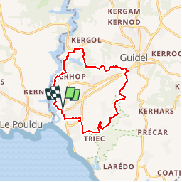
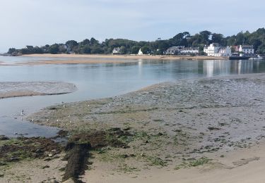
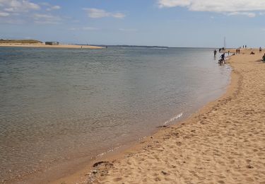
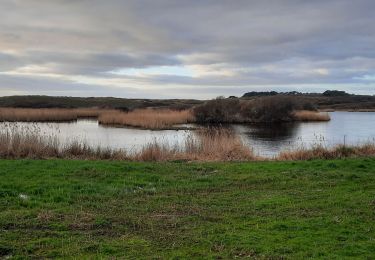
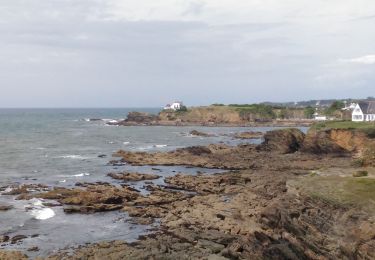
Trail Walking of 12.2 km to be discovered at Brittany, Morbihan, Guidel. This trail is proposed by CHEVE.

Description

Randonnée à peine modifiée de du circuit N°7 proposé par l'Office de Tourisme du Pays de Lorient.
Voir aussi une autre rando allongée dans ce même secteur.

Elevation profile

Points of interest

Point of interest Guidel - Pt1 - Photo
CHEVE
GUIDEL 
Point of interest Guidel - Pt3 - Photo
CHEVE
GUIDEL 
Point of interest Guidel - Pt4 - Photo
CHEVE
GUIDEL 
Point of interest Guidel - Pt5 - Photo
CHEVE
GUIDEL 
Point of interest Guidel - Pt6 - Photo
CHEVE
GUIDEL 
Point of interest Guidel - Pt7 - Photo
CHEVE
GUIDEL 
Point of interest Guidel - Pt8 - Photo
CHEVE
GUIDEL 
Point of interest Guidel - Pt9 - Photo
CHEVE
GUIDEL 
Point of interest Guidel - P10 - Photo
CHEVE
GUIDEL 
Point of interest Guidel - P11 - Photo
CHEVE
GUIDEL 
Point of interest Guidel - P12 - Photo
CHEVE
GUIDEL 
Point of interest Guidel - P13 - Photo
CHEVE
GUIDEL 
Point of interest Guidel - P14 - Photo
CHEVE
GUIDEL 
Point of interest Guidel - P15 - Photo
CHEVE
GUIDEL 
Point of interest Guidel - P16 - Photo
CHEVE
GUIDEL 
Point of interest Guidel - P17 - Photo
CHEVE
GUIDEL 
Point of interest Guidel - P18 - Photo
CHEVE
GUIDEL 

Positioning

Country:
France
Region :
Brittany
Department/Province :
Morbihan
Municipality :
Guidel
Location:
Unknown
Start:(UTM)
460594 ; 5291145 (30T) N.

Trails nearby

Trail On foot Plœmeur - De la côte bleue aux collines blanches - Photo
On foot
PRO

On foot

Easy
Plœmeur, Brittany, Morbihan, France
9.1 km | 10 km-effort
2h 16min
No
Trail Walking Guidel - Guidel plage 7,6 km - Photo
Walking
GUIDE
rvapeldo

Walking

Easy
Guidel, Brittany, Morbihan, France
7.6 km | 8.5 km-effort
2h 11min
Yes
Trail Walking Clohars-Carnoët - Pouldu port peintres 6,3 km - Photo
Walking
GUIDE
rvapeldo

Walking

Easy
Clohars-Carnoët, Brittany, Finistère, France
6.3 km | 7.2 km-effort
2h 12min
Yes
Trail Walking Clohars-Carnoët - Pouldu Roche Percée et retour 9,5 km - Photo
Walking
GUIDE
rvapeldo

Walking

Medium
Clohars-Carnoët, Brittany, Finistère, France
9.5 km | 10.7 km-effort
2h 46min
Yes
Trail Walking Guidel - PR_56_Guidel_BA_02_Circuit3b_Entre-Loch-Et-Laita_20231004 - Photo
Walking
patrickdanilo

Walking

Easy
Guidel, Brittany, Morbihan, France
13.4 km | 15.7 km-effort
3h 34min
Yes
Trail Walking Guidel - laita - Photo
Walking
dcharbonnier

Walking

Medium
Guidel, Brittany, Morbihan, France
9.8 km | 12 km-effort
3h 58min
Yes
Trail Electric bike Clohars-Carnoët - Moelans Pontivy par les berges du Blavet - Photo
Electric bike
ilefebvre

Electric bike

Very easy
Clohars-Carnoët, Brittany, Finistère, France
81 km | 94 km-effort
4h 43min
No
Trail Walking Guidel - PR_56_Guidel_AA_01_Circuit3b_Autour-Du-Loc'h_20220120 - Photo
Walking
patrickdanilo

Walking

Medium
Guidel, Brittany, Morbihan, France
9.8 km | 11.2 km-effort
2h 16min
Yes
Trail Walking Clohars-Carnoët - Remontée de la Laïta de Guidel au Pouldu - Photo
Walking
ilur56

Walking

Easy
Clohars-Carnoët, Brittany, Finistère, France
18.7 km | 22 km-effort
6h 53min
Yes


Close
My subscriptions