Trail Walking Chancenay - Chancenay  - Photo
 Jeff_314
Jeff_314

User

© OpenStreetMap contributors
Length
Length
5.2 km
Max alt
Max alt
208 m
Uphill gradient
Uphill gradient
82 m
Km-Effort
Km-Effort  
6.2 km
Min alt
Min alt
156 m
Downhill gradient
Downhill gradient
77 m
Boucle
Boucle
Yes
Creation date :
2014-12-10 00:00:00.0
Updated on :
2014-12-10 00:00:00.0

(0 Reviews)

Walking
Walking
1h33
Difficulty : Easy

Scan this QR Code to open this trail in the SityTrail application

FREE GPS app for hiking

Logo SityTrail SityTrail

IGN / Geographical institutes

Download SityTrail from the App Store Download SityTrail from Google Play

Logo SityTrail SityTrail World

The world is yours!

Download SityTrail from the App Store Download SityTrail from Google Play Download SityTrail on Huawei AppGallery

About

Trail Walking of 5.2 km to be discovered at Grand Est, Haute-Marne, Chancenay. This trail is proposed by Jeff_314.

Description

ancienne voie de chemin de fer et autres chemins...

Elevation profile

Positioning

Country:
France
Region :
Grand Est
Department/Province :
Haute-Marne
Municipality :
Chancenay
Location:
Unknown
Start:(UTM)
646488 ; 5392597 (31U) N.

Trails nearby

Trail Walking Ancerville - anceevilleforet de valtiermont - Photo
Walking
ghislaine61

Walking

Easy
Ancerville, Grand Est, Meuse, France
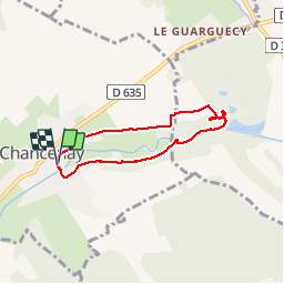
9.1 km | 10.5 km-effort
2h 46min
Yes
Trail Walking Trois-Fontaines-l'Abbaye - zone industriel après robert espagne - Photo
Walking
ghislaine61

Walking

Easy
Trois-Fontaines-l'Abbaye, Grand Est, Marne, France
9.9 km | 11.6 km-effort
2h 56min
Yes
Trail Walking Saint-Dizier - 8 mai Nadine - Photo
Walking
René Kovac

Walking

Saint-Dizier, Grand Est, Haute-Marne, France
10.4 km | 11.2 km-effort
3h 4min
Yes
Trail Walking Bettancourt-la-Ferrée - Bettancourt stade Bernard - Photo
Walking
René Kovac

Walking

Bettancourt-la-Ferrée, Grand Est, Haute-Marne, France
8.4 km | 9.5 km-effort
2h 18min
Yes
Trail Walking Ancerville - Le Bruly - Claude belle marche  - Photo
Walking
René Kovac

Walking

Ancerville, Grand Est, Meuse, France
9.2 km | 10.9 km-effort
2h 55min
Yes
Trail Walking Ancerville - Ancerville virage Nadine - Photo
Walking
René Kovac

Walking

Ancerville, Grand Est, Meuse, France
7.5 km | 8.9 km-effort
2h 29min
Yes
Trail Walking Saint-Dizier - Electre raccourci pluie - Photo
Walking
René Kovac

Walking

Saint-Dizier, Grand Est, Haute-Marne, France
6.2 km | 7.5 km-effort
1h 25min
Yes
Trail Walking Chancenay - Chancenay petite marche vin chaud  - Photo
Walking
René Kovac

Walking

Chancenay, Grand Est, Haute-Marne, France
5.8 km | 6.9 km-effort
2h 28min
Yes
Trail Walking Ancerville - Bruly - Photo
Walking
René Kovac

Walking

Ancerville, Grand Est, Meuse, France
9.3 km | 10.8 km-effort
2h 58min
Yes


Close
My subscriptions