Trail Walking Saint-Péray - N_ST PERAY 07130 Baume des Bois - Crussol - Photo

N_ST PERAY 07130 Baume des Bois - Crussol

 ANDREJAC
ANDREJAC

User

© OpenStreetMap contributors
Length
Length
4.2 km
Max alt
Max alt
387 m
Uphill gradient
Uphill gradient
191 m
Km-Effort
Km-Effort  
6.8 km
Min alt
Min alt
212 m
Downhill gradient
Downhill gradient
192 m
Boucle
Boucle
Yes
Creation date :
2014-12-10 00:00:00.0
Updated on :
2014-12-10 00:00:00.0

(2 Reviews)

Walking
Walking
1h40
Difficulty : Easy

Scan this QR Code to open this trail in the SityTrail application

FREE GPS app for hiking

Logo SityTrail SityTrail

IGN / Geographical institutes

Download SityTrail from the App Store Download SityTrail from Google Play

Logo SityTrail SityTrail World

The world is yours!

Download SityTrail from the App Store Download SityTrail from Google Play Download SityTrail on Huawei AppGallery

About

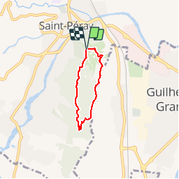
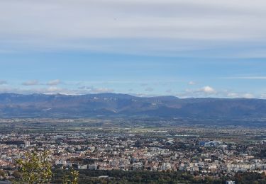
Trail Walking of 4.2 km to be discovered at Auvergne-Rhône-Alpes, Ardèche, Saint-Péray. This trail is proposed by ANDREJAC.

Description

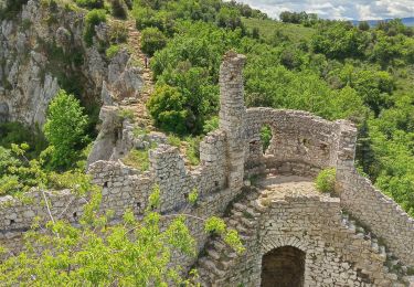
Départ du parking Vallat ; vers le sud au delà de baume des Bois, vers la crête à la côte 386, vers le nord jusqu''au château de Crussol, retour à Vallat.

Elevation profile

Positioning

Country:
France
Region :
Auvergne-Rhône-Alpes
Department/Province :
Ardèche
Municipality :
Saint-Péray
Location:
Unknown
Start:(UTM)
645816 ; 4978078 (31T) N.

Comments

Please log in to post a review or rate the element


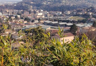
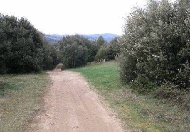
Deuxième partie en crêtes trés agréable


Trails nearby

Trail Mountain bike Saint-Péray - Boucle VTT autour de Saint Péray - Photo
Mountain bike
tracegps

Mountain bike

Difficult
(5)
Saint-Péray, Auvergne-Rhône-Alpes, Ardèche, France
31 km | 41 km-effort
2h 0min
Yes
Trail Walking Toulaud - Château de Crussol par Meyret - Photo
Walking
crocau

Walking

Medium
(1)
Toulaud, Auvergne-Rhône-Alpes, Ardèche, France
7.6 km | 11.1 km-effort
3h 14min
Yes
Trail Walking Cornas - De Cornas à la Borne - Photo
Walking
Gilbertbancilhon

Walking

Difficult
(1)
Cornas, Auvergne-Rhône-Alpes, Ardèche, France
12.3 km | 18.3 km-effort
4h 51min
Yes
Trail Walking Toulaud - 07 toulaud  - Photo
Walking
himba26100

Walking

Very easy
Toulaud, Auvergne-Rhône-Alpes, Ardèche, France
7.1 km | 10.9 km-effort
2h 24min
Yes
Trail Walking Saint-Péray - St Peray - Photo
Walking
ajd26

Walking

Difficult
Saint-Péray, Auvergne-Rhône-Alpes, Ardèche, France
7.6 km | 12.4 km-effort
2h 49min
Yes
Trail Walking Saint-Péray - saint peray - Photo
Walking
AIGUIER

Walking

Difficult
(1)
Saint-Péray, Auvergne-Rhône-Alpes, Ardèche, France
15 km | 23 km-effort
5h 19min
Yes
Trail Walking Saint-Péray - Le château de Crussol et ses crêtes  - Photo
Walking
prv

Walking

Easy
Saint-Péray, Auvergne-Rhône-Alpes, Ardèche, France
9.9 km | 14.1 km-effort
2h 27min
Yes
Trail Walking Saint-Romain-de-Lerps - barbara - Photo
Walking
Babriders

Walking

Very easy
Saint-Romain-de-Lerps, Auvergne-Rhône-Alpes, Ardèche, France
4.9 km | 6.5 km-effort
1h 25min
Yes
Trail Mountain bike Guilherand-Granges - guilherand-st peray-tracol-st peray-Cornas-guilherand - Photo
Mountain bike
aps07

Mountain bike

Medium
Guilherand-Granges, Auvergne-Rhône-Alpes, Ardèche, France
30 km | 36 km-effort
3h 1min
Yes


Close
My subscriptions