Trail Walking Saint-Louis-lès-Bitche - Voie ferrée militaire de Saint-Louis à Simserhof - Ligne Maginot - Photo

Voie ferrée militaire de Saint-Louis à Simserhof - Ligne Maginot

 tracegps
tracegps

User

© OpenStreetMap contributors
Length
Length
27 km
Max alt
Max alt
422 m
Uphill gradient
Uphill gradient
565 m
Km-Effort
Km-Effort  
34 km
Min alt
Min alt
263 m
Downhill gradient
Downhill gradient
493 m
Boucle
Boucle
No
Creation date :
2014-12-10 00:00:00.0
Updated on :
2014-12-10 00:00:00.0

(0 Reviews)

Walking
Walking
6h00
Difficulty : Difficult

Scan this QR Code to open this trail in the SityTrail application

FREE GPS app for hiking

Logo SityTrail SityTrail

IGN / Geographical institutes

Download SityTrail from the App Store Download SityTrail from Google Play

Logo SityTrail SityTrail World

The world is yours!

Download SityTrail from the App Store Download SityTrail from Google Play Download SityTrail on Huawei AppGallery

About

Trail Walking of 27 km to be discovered at Grand Est, Moselle, Saint-Louis-lès-Bitche. This trail is proposed by tracegps.

Description

Le parcours débute à la gare d'échange de Saint-Louis-lès-Bitche où arrivaient les trains de munitions en provenance de Wingen-sur-Moder. Les munitions étaient déchargées des wagons à écartement normal (1,435m) sur des wagonnets à écartement 60cm. A la gare militaire de Saint-Louis étaient entretenus les locomotives et les wagons dans des ateliers dont il subsiste encore les soubassements et le château d'eau. De nombreux fossés, aqueducs, ponceaux, murs de soutènement sont encore visibles sur le parcours transformé en chemin forestier avec le ballast. Des parties de voie en tranchée ou en remblai laissent deviner l'existence d'une voie ferrée. Deux parties de voie en heutoir permettaient de rebrousser pour franchir la colline du Légeret. Devant l'entrée des munitions du Simserhof stationnent des wagonnets témoins de cette ligne qui ne demande qu'à être valorisée par un balisage pédestre pour en permettre plus facilement la randonnée. Téléchargez la carte du trajet .

Elevation profile

Photos

Positioning

Country:
France
Region :
Grand Est
Department/Province :
Moselle
Municipality :
Saint-Louis-lès-Bitche
Location:
Unknown
Start:(Dec)
Start:(UTM)
377591 ; 5427196 (32U) N.

Trails nearby

Trail Walking Saint-Louis-lès-Bitche - Saint-Louis-Lès-Bitche et le pays du verre et du cristal - Photo
Walking
tracegps

Walking

Medium
(2)
Saint-Louis-lès-Bitche, Grand Est, Moselle, France
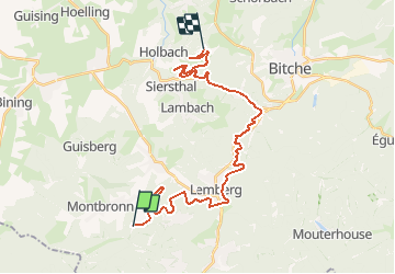
13.1 km | 17.5 km-effort
3h 19min
Yes
Trail On foot Montbronn - Wayside crosses tour No. 4 - Photo
On foot
PRO

On foot

Easy
Montbronn, Grand Est, Moselle, France
4.9 km | 6.2 km-effort
1h 24min
No
Trail On foot Butten - Anneau bleu - Photo
On foot
PRO

On foot

Easy
Butten, Grand Est, Bas-Rhin, France
5.8 km | 7.9 km-effort
1h 48min
Yes
Trail On foot Butten - Anneau rouge - Photo
On foot
PRO

On foot

Easy
Butten, Grand Est, Bas-Rhin, France
6.2 km | 8 km-effort
1h 48min
Yes
Trail On foot Volksberg - Anneau vert - Photo
On foot
PRO

On foot

Easy
Volksberg, Grand Est, Bas-Rhin, France
5.6 km | 7.6 km-effort
1h 43min
Yes
Trail On foot Meisenthal - Following in the footsteps of the Glass and Clog makers - Tour 2 - Photo
On foot
PRO

On foot

Easy
Meisenthal, Grand Est, Moselle, France
12.2 km | 16.7 km-effort
3h 47min
Yes
Trail On foot Meisenthal - Mooncatchers permanent trail - 20 km - Photo
On foot
PRO

On foot

Easy
Meisenthal, Grand Est, Moselle, France
8.8 km | 11.7 km-effort
2h 39min
No
Trail On foot Soucht - Mooncatchers permanent trail - 10 km - Photo
On foot
PRO

On foot

Easy
Soucht, Grand Est, Moselle, France
9.3 km | 12.5 km-effort
2h 50min
Yes
Trail On foot Goetzenbruck - Goetzenbruck fountains and washing places tour - Photo
On foot
PRO

On foot

Easy
Goetzenbruck, Grand Est, Moselle, France
6.7 km | 9.1 km-effort
2h 4min
Yes


Close
My subscriptions