Trail Cycle Wolxheim - Circuit Cyclotourisme de Soultz-les-Bains - Photo

Circuit Cyclotourisme de Soultz-les-Bains

 tracegps
tracegps

User

© OpenStreetMap contributors
Length
Length
9.8 km
Max alt
Max alt
178 m
Uphill gradient
Uphill gradient
53 m
Km-Effort
Km-Effort  
10.5 km
Min alt
Min alt
160 m
Downhill gradient
Downhill gradient
52 m
Boucle
Boucle
Yes
Creation date :
2014-12-10 00:00:00.0
Updated on :
2014-12-10 00:00:00.0

(0 Reviews)

Cycle
Cycle
30m
Difficulty : Easy

Scan this QR Code to open this trail in the SityTrail application

FREE GPS app for hiking

Logo SityTrail SityTrail

IGN / Geographical institutes

Download SityTrail from the App Store Download SityTrail from Google Play

Logo SityTrail SityTrail World

The world is yours!

Download SityTrail from the App Store Download SityTrail from Google Play Download SityTrail on Huawei AppGallery

About

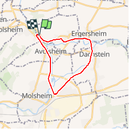
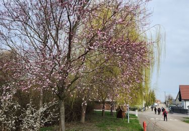
Trail Cycle of 9.8 km to be discovered at Grand Est, Bas-Rhin, Wolxheim. This trail is proposed by tracegps.

Description

De nombreuses pistes cyclables offrent la possibilité de découvrir la région Molsheim – Mutzig. Départ de Soultz-les-Bains. Retrouvez le circuit sur le site de l'Office de Tourisme de Molsheim – Mutzig.

Elevation profile

Photos

Positioning

Country:
France
Region :
Grand Est
Department/Province :
Bas-Rhin
Municipality :
Wolxheim
Location:
Unknown
Start:(Dec)
Start:(UTM)
388910 ; 5380640 (32U) N.

Trails nearby

Trail Walking Mutzig - Les sanctuaires autour de Mutzig - Photo
Walking
VacheKiri67

Walking

Medium
(1)
Mutzig, Grand Est, Bas-Rhin, France
13.6 km | 17.9 km-effort
5h 0min
Yes
Trail Walking Wolxheim - wolxheim, chapelle st-denis. - Photo
Walking
jo-da

Walking

Medium
(1)
Wolxheim, Grand Est, Bas-Rhin, France
6.9 km | 8.3 km-effort
2h 19min
Yes
Trail Walking Mutzig - Les sanctuaires autour de Mutzig - Photo
Walking
tracegps

Walking

Difficult
(1)
Mutzig, Grand Est, Bas-Rhin, France
12.7 km | 16.8 km-effort
4h 0min
Yes
Trail Walking Dorlisheim - Escapade dans le vignoble de Dorlisheim - Photo
Walking
tracegps

Walking

Medium
(1)
Dorlisheim, Grand Est, Bas-Rhin, France
9.7 km | 12.6 km-effort
3h 0min
Yes
Trail Walking Mutzig - Autour du Fort de Mutzig - Photo
Walking
VacheKiri67

Walking

Difficult
(2)
Mutzig, Grand Est, Bas-Rhin, France
18.7 km | 26 km-effort
6h 30min
Yes
Trail Walking Molsheim - Les Chapelles entre vignoble et canal - Photo
Walking
VacheKiri67

Walking

Medium
(2)
Molsheim, Grand Est, Bas-Rhin, France
14.8 km | 17 km-effort
3h 43min
Yes
Trail Mountain bike Dinsheim-sur-Bruche - Les Grandes Manoeuvres - Photo
Mountain bike
tracegps

Mountain bike

Very difficult
(1)
Dinsheim-sur-Bruche, Grand Est, Bas-Rhin, France
45 km | 59 km-effort
4h 0min
Yes
Trail Horseback riding Westhoffen - 2023-04-23 Picnic CVA La Mercière depuis Westhoffen - Photo
Horseback riding
GUIDE
holtzv

Horseback riding

Medium
Westhoffen, Grand Est, Bas-Rhin, France
31 km | 43 km-effort
5h 28min
Yes
Trail Nordic walking Bergbieten - Bergbieten 20240307 - Photo
Nordic walking
Michel 67170

Nordic walking

Very easy
Bergbieten, Grand Est, Bas-Rhin, France
11.3 km | 15.3 km-effort
2h 42min
Yes


Close
My subscriptions