Trail Mountain bike Taverny - La Tabernacienne 2013 - Taverny - Photo

La Tabernacienne 2013 - Taverny

 tracegps
tracegps

User

© OpenStreetMap contributors
Length
Length
32 km
Max alt
Max alt
202 m
Uphill gradient
Uphill gradient
528 m
Km-Effort
Km-Effort  
39 km
Min alt
Min alt
68 m
Downhill gradient
Downhill gradient
529 m
Boucle
Boucle
Yes
Creation date :
2014-12-10 00:00:00.0
Updated on :
2014-12-10 00:00:00.0

(1 Reviews)

Mountain bike
Mountain bike
2h30
Difficulty : Medium

Scan this QR Code to open this trail in the SityTrail application

FREE GPS app for hiking

Logo SityTrail SityTrail

IGN / Geographical institutes

Download SityTrail from the App Store Download SityTrail from Google Play

Logo SityTrail SityTrail World

The world is yours!

Download SityTrail from the App Store Download SityTrail from Google Play Download SityTrail on Huawei AppGallery

About

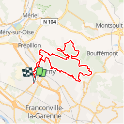
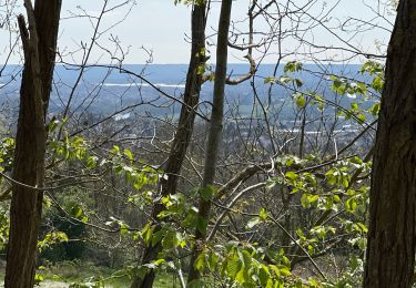
Trail Mountain bike of 32 km to be discovered at Ile-de-France, Val-d'Oise, Taverny. This trail is proposed by tracegps.

Description

Rando VTT La Tabernacienne 2013 au départ de Taverny, rue Philippe Leraudat, pour une sortie en forêt de Montmorency.

Elevation profile

Photos

Positioning

Country:
France
Region :
Ile-de-France
Department/Province :
Val-d'Oise
Municipality :
Taverny
Location:
Unknown
Start:(UTM)
442279 ; 5429516 (31U) N.

Comments

Please log in to post a review or rate the element


Trails nearby

Trail Walking Frépillon - GRP CV-IDF 2023 - Photo
Walking
clalaur

Walking

Very difficult
(1)
Frépillon, Ile-de-France, Val-d'Oise, France
16 km | 20 km-effort
4h 32min
No
Trail Walking Taverny - Boucle en forêt à partir de Taverny - Photo
Walking
tracegps

Walking

Medium
(1)
Taverny, Ile-de-France, Val-d'Oise, France
12.3 km | 15.8 km-effort
3h 30min
Yes
Trail Equestrian Taverny - Rando testé Montmorency l'isle adam 23km - Photo
Equestrian
unirega

Equestrian

Medium
(2)
Taverny, Ile-de-France, Val-d'Oise, France
25 km | 31 km-effort
3h 51min
Yes
Trail Mountain bike Saint-Leu-la-Forêt - Montmorency - Photo
Mountain bike
sylvain75

Mountain bike

Medium
(2)
Saint-Leu-la-Forêt, Ile-de-France, Val-d'Oise, France
23 km | 30 km-effort
Unknown
Yes
Trail Walking Méry-sur-Oise - Méry sur OIse- Neuville université - Photo
Walking
chessyca

Walking

Very easy
Méry-sur-Oise, Ile-de-France, Val-d'Oise, France
15.6 km | 17.7 km-effort
3h 37min
No
Trail Walking Cormeilles-en-Parisis - Aller-Retour - Le balcon de l'Ile de France - Cormeilles en Parisis - Photo
Walking
Vadim

Walking

Easy
Cormeilles-en-Parisis, Ile-de-France, Val-d'Oise, France
10.5 km | 13.4 km-effort
2h 13min
Yes
Trail Walking Chauvry - Foutue route vers Baillet - Photo
Walking
csy95

Walking

Medium
(1)
Chauvry, Ile-de-France, Val-d'Oise, France
19.1 km | 24 km-effort
5h 20min
Yes
Trail Walking Ermont - Ermont-Lac d'enghien - Photo
Walking
csy95

Walking

Difficult
(1)
Ermont, Ile-de-France, Val-d'Oise, France
11.6 km | 12.5 km-effort
2h 49min
Yes
Trail Walking Frépillon - SityTrail - GRP CV-IDF - Photo
Walking
clalaur

Walking

Easy
Frépillon, Ile-de-France, Val-d'Oise, France
15.3 km | 18.2 km-effort
4h 30min
No


Close
My subscriptions