


Aosta Vétan

Cardinje
User
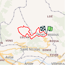

Length
10.1 km

Max alt
2155 m

Uphill gradient
537 m
Km-Effort
17.3 km

Min alt
1636 m

Downhill gradient
544 m
Boucle
Yes
Creation date :
2019-04-05 13:48:20.756
Updated on :
2019-04-05 13:48:20.79
3h50
Difficulty : Easy

FREE GPS app for hiking
 SityTrail
IGN / Geographical institutes
SityTrail Plus
The world is yours!
About
Trail Walking of 10.1 km to be discovered at Aosta Valley, Unknown, Saint-Pierre. This trail is proposed by Cardinje.
Description
Val d''Aoste
Positioning
Country:
Italy
Region :
Aosta Valley
Department/Province :
Unknown
Municipality :
Saint-Pierre
Location:
Unknown
Start:(Dec)
Start:(UTM)
359198 ; 5065674 (32T) N.
Comments