


Aosta Lac des Grenouilles

Cardinje
User
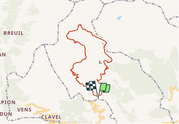

Length
14.6 km

Max alt
2520 m

Uphill gradient
864 m
Km-Effort
26 km

Min alt
1679 m

Downhill gradient
847 m
Boucle
Yes
Creation date :
2019-04-05 13:48:19.906
Updated on :
2019-04-05 13:48:19.942
5h24
Difficulty : Very easy

FREE GPS app for hiking
 SityTrail
IGN / Geographical institutes
SityTrail Plus
The world is yours!
About
Trail Walking of 14.6 km to be discovered at Aosta Valley, Unknown, Saint-Pierre. This trail is proposed by Cardinje.
Description
Val D''Aoste
Positioning
Country:
Italy
Region :
Aosta Valley
Department/Province :
Unknown
Municipality :
Saint-Pierre
Location:
Unknown
Start:(Dec)
Start:(UTM)
359220 ; 5065578 (32T) N.
Comments