


Cascade de Chaumié

jmheydorff
User
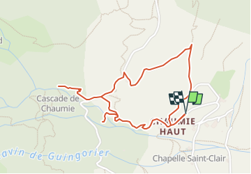

Length
2.6 km

Max alt
1638 m

Uphill gradient
232 m
Km-Effort
5.7 km

Min alt
1419 m

Downhill gradient
232 m
Boucle
Yes
Creation date :
2014-12-10 00:00:00.0
Updated on :
2024-04-26 06:53:07.347
1h17
Difficulty : Easy

FREE GPS app for hiking
 SityTrail
IGN / Geographical institutes
SityTrail Plus
The world is yours!
About
Trail Walking of 2.6 km to be discovered at Provence-Alpes-Côte d'Azur, Alpes-de-Haute-Provence, Colmars. This trail is proposed by jmheydorff.
Description
Pkg près de la chapelle St Clair à Chaumié haut.
remonter le ruisseau de la Cascade sur 1km, et revenir par un sentier au Nord de Chaumié haut.
Positioning
Country:
France
Region :
Provence-Alpes-Côte d'Azur
Department/Province :
Alpes-de-Haute-Provence
Municipality :
Colmars
Location:
Unknown
Start:(Dec)
Start:(UTM)
310680 ; 4897453 (32T) N.
Comments