Trail Walking Ruy-Montceau - Rando GODAS 12 km juin 2013 - Photo

Rando GODAS 12 km juin 2013

 bourset
bourset

User

© OpenStreetMap contributors
Length
Length
11.9 km
Max alt
Max alt
480 m
Uphill gradient
Uphill gradient
230 m
Km-Effort
Km-Effort  
15 km
Min alt
Min alt
415 m
Downhill gradient
Downhill gradient
229 m
Boucle
Boucle
Yes
Creation date :
2014-12-10 00:00:00.0
Updated on :
2014-12-10 00:00:00.0

(0 Reviews)

Walking
Walking
3h11
Difficulty : Medium

Scan this QR Code to open this trail in the SityTrail application

FREE GPS app for hiking

Logo SityTrail SityTrail

IGN / Geographical institutes

Download SityTrail from the App Store Download SityTrail from Google Play

Logo SityTrail SityTrail World

The world is yours!

Download SityTrail from the App Store Download SityTrail from Google Play Download SityTrail on Huawei AppGallery

About

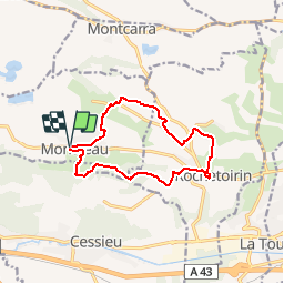
Trail Walking of 11.9 km to be discovered at Auvergne-Rhône-Alpes, Isère, Ruy-Montceau. This trail is proposed by bourset.

Description

Parcours moyen fléché bleu proposé par l'association les Godas lors de la "Randonnée de Kiki le 2 juin 2013

Elevation profile

Positioning

Country:
France
Region :
Auvergne-Rhône-Alpes
Department/Province :
Isère
Municipality :
Ruy-Montceau
Location:
Unknown
Start:(UTM)
685219 ; 5050959 (31T) N.

Trails nearby

Trail Walking Vignieu - Vignieu - Saint Chef - Canal des moines  - Photo
Walking

Walking

Very difficult
Vignieu, Auvergne-Rhône-Alpes, Isère, France
15.6 km | 20 km-effort
4h 34min
Yes
Trail Walking Cessieu - Cessieu - Photo
Walking
alphonse22

Walking

Cessieu, Auvergne-Rhône-Alpes, Isère, France
8.2 km | 11.5 km-effort
2h 58min
Yes
Trail Walking Cessieu - Cessieu  - Photo
Walking
alphonse22

Walking

Cessieu, Auvergne-Rhône-Alpes, Isère, France
10.5 km | 14.7 km-effort
3h 8min
Yes
Trail Walking Cessieu - Cessiez - Photo
Walking
alphonse22

Walking

Cessieu, Auvergne-Rhône-Alpes, Isère, France
5.5 km | 7.3 km-effort
2h 11min
No
Trail Walking Saint-Jean-de-Soudain - 2013 09 15 St-Jean de Soudain - Photo
Walking
lechner

Walking

Very easy
Saint-Jean-de-Soudain, Auvergne-Rhône-Alpes, Isère, France
16.7 km | 20 km-effort
1h 14min
Yes
Trail Equestrian Saint-Victor-de-Cessieu - plaine GLAMS - Photo
Equestrian
tifilou38

Equestrian

Very easy
Saint-Victor-de-Cessieu, Auvergne-Rhône-Alpes, Isère, France
17.3 km | 19.3 km-effort
2h 0min
Yes
Trail Walking Montcarra - Sur les hauteurs de Montcarra - Photo
Walking
frdy69

Walking

Easy
(1)
Montcarra, Auvergne-Rhône-Alpes, Isère, France
6.8 km | 8 km-effort
1h 44min
Yes
Trail Mountain bike Rochetoirin - rochetoirin - Photo
Mountain bike
magyar

Mountain bike

Very easy
Rochetoirin, Auvergne-Rhône-Alpes, Isère, France
16.5 km | 21 km-effort
Unknown
Yes
Trail Walking Vignieu - vigneu chevaux - Photo
Walking
jjjf01

Walking

Very easy
Vignieu, Auvergne-Rhône-Alpes, Isère, France
3.6 km | 4.3 km-effort
1h 26min
Yes


Close
My subscriptions