Trail Walking Vacheresse - Ubine -> chalets Autigny AR - Photo

Ubine -> chalets Autigny AR

© OpenStreetMap contributors
Length
Length
5.8 km
Max alt
Max alt
1581 m
Uphill gradient
Uphill gradient
190 m
Km-Effort
Km-Effort  
8.3 km
Min alt
Min alt
1477 m
Downhill gradient
Downhill gradient
193 m
Boucle
Boucle
Yes
Creation date :
2014-12-10 00:00:00.0
Updated on :
2014-12-10 00:00:00.0

(0 Reviews)

Walking
Walking
1h55
Difficulty : Easy

Scan this QR Code to open this trail in the SityTrail application

FREE GPS app for hiking

Logo SityTrail SityTrail

IGN / Geographical institutes

Download SityTrail from the App Store Download SityTrail from Google Play

Logo SityTrail SityTrail World

The world is yours!

Download SityTrail from the App Store Download SityTrail from Google Play Download SityTrail on Huawei AppGallery

About

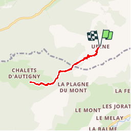
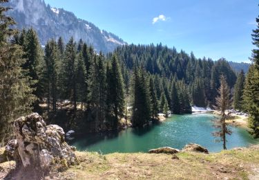
Trail Walking of 5.8 km to be discovered at Auvergne-Rhône-Alpes, Upper Savoy, Vacheresse. This trail is proposed by alaindurbecq.

Description

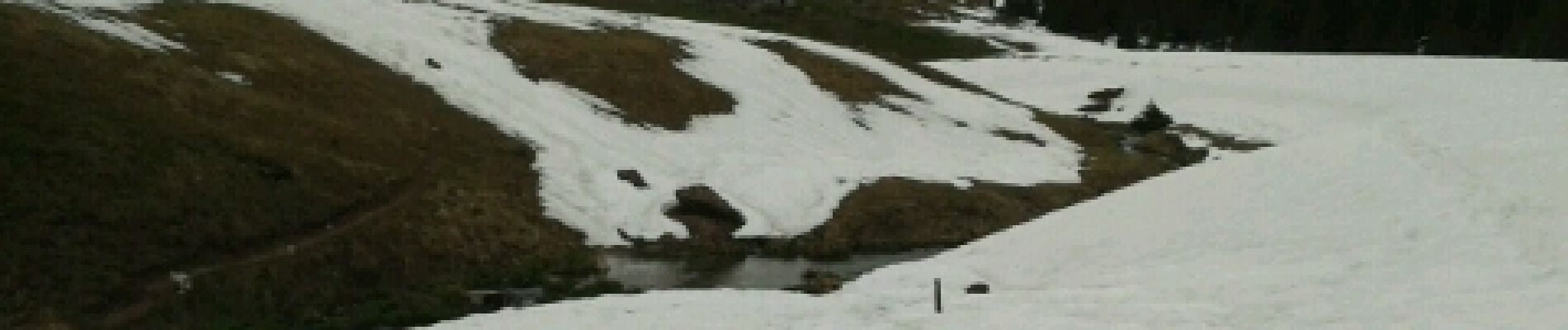
Balade facile et qui ouvre sur de beaux points de vue. En début de saison (ici mi-mai),la neige peut rendre difficle le repérage du tracé. A prolonger jusqu'à la pointe d'Autigny
         

Elevation profile

Photos

Positioning

Country:
France
Region :
Auvergne-Rhône-Alpes
Department/Province :
Upper Savoy
Municipality :
Vacheresse
Location:
Unknown
Start:(UTM)
326153 ; 5130610 (32T) N.

Trails nearby

Trail Walking Bernex - Dent d'Oche - coucher de soleil  - Photo
Walking
dalla.anthony

Walking

Medium
(4)
Bernex, Auvergne-Rhône-Alpes, Upper Savoy, France
9.2 km | 22 km-effort
3h 13min
Yes
Trail Walking La Chapelle-d'Abondance - Les Cornettes de Bise par le sentier de Saix Rouquin - Photo
Walking
tracegps

Walking

Difficult
(1)
La Chapelle-d'Abondance, Auvergne-Rhône-Alpes, Upper Savoy, France
10 km | 25 km-effort
6h 30min
Yes
Trail Walking La Chapelle-d'Abondance - Cascade boucle 2 - Photo
Walking
Derrendinger

Walking

Difficult
(1)
La Chapelle-d'Abondance, Auvergne-Rhône-Alpes, Upper Savoy, France
10.1 km | 14.9 km-effort
3h 23min
Yes
Trail Walking La Chapelle-d'Abondance - lac darbon - Photo
Walking
tof38

Walking

Easy
(1)
La Chapelle-d'Abondance, Auvergne-Rhône-Alpes, Upper Savoy, France
5.9 km | 13.7 km-effort
3h 54min
No
Trail Walking Bernex - Boucle depuis Pre Richard.. - Photo
Walking
tyax93

Walking

Medium
Bernex, Auvergne-Rhône-Alpes, Upper Savoy, France
10 km | 19.6 km-effort
4h 46min
Yes
Trail Walking Vacheresse - Tour du Mont Chauffé  - Photo
Walking
reneperrin

Walking

Medium
Vacheresse, Auvergne-Rhône-Alpes, Upper Savoy, France
12.7 km | 23 km-effort
5h 12min
Yes
Trail Walking La Chapelle-d'Abondance - CORNETTES DE BISE: LAC DE DARBON - Photo
Walking
djeepee74

Walking

Medium
La Chapelle-d'Abondance, Auvergne-Rhône-Alpes, Upper Savoy, France
7.7 km | 16 km-effort
3h 30min
Yes
Trail Walking Vacheresse - Ubine, col d'Ubine, col des Mosses, chalets de Bise, lac de Fontaine - Photo
Walking
reneperrin

Walking

Medium
Vacheresse, Auvergne-Rhône-Alpes, Upper Savoy, France
8.6 km | 15.6 km-effort
6h 13min
No
Trail On foot Abondance - Itineraire des bords de Dranse - Photo
On foot
PRO

On foot

Easy
Abondance, Auvergne-Rhône-Alpes, Upper Savoy, France
3.6 km | 4.4 km-effort
59min
No


Close
My subscriptions