


Chemin Assise - St Christophe St Hugues

mmx007
User

Length
20 km

Max alt
1451 m

Uphill gradient
1291 m
Km-Effort
36 km

Min alt
424 m

Downhill gradient
842 m
Boucle
No
Creation date :
2014-12-10 00:00:00.0
Updated on :
2014-12-10 00:00:00.0
7h48
Difficulty : Difficult

FREE GPS app for hiking
 SityTrail
IGN / Geographical institutes
SityTrail Plus
The world is yours!
About
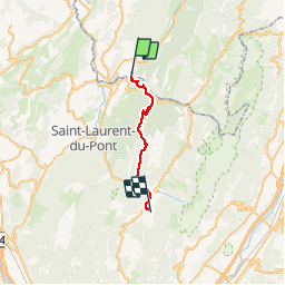
Trail Walking of 20 km to be discovered at Auvergne-Rhône-Alpes, Savoy, Saint-Christophe. This trail is proposed by mmx007.
Description
Variante de St Christophe à St Hugues, sur les pas de Bernard de Clairvaux
Positioning
Country:
France
Region :
Auvergne-Rhône-Alpes
Department/Province :
Savoy
Municipality :
Saint-Christophe
Location:
Unknown
Start:(Dec)
Start:(UTM)
717607 ; 5035937 (31T) N.
Comments