Trail Bicycle tourism Auch - B - Auch - Coeurs de Gascogne - Photo

B - Auch - Coeurs de Gascogne

 potofe
potofe

User

© OpenStreetMap contributors
Length
Length
129 km
Max alt
Max alt
287 m
Uphill gradient
Uphill gradient
1966 m
Km-Effort
Km-Effort  
155 km
Min alt
Min alt
114 m
Downhill gradient
Downhill gradient
1966 m
Boucle
Boucle
Yes
Creation date :
2018-09-07 19:24:31.88
Updated on :
2018-11-01 10:02:05.439

(0 Reviews)

Bicycle tourism
Bicycle tourism
--
Difficulty : Medium

Scan this QR Code to open this trail in the SityTrail application

FREE GPS app for hiking

Logo SityTrail SityTrail

IGN / Geographical institutes

Download SityTrail from the App Store Download SityTrail from Google Play

Logo SityTrail SityTrail World

The world is yours!

Download SityTrail from the App Store Download SityTrail from Google Play Download SityTrail on Huawei AppGallery

About

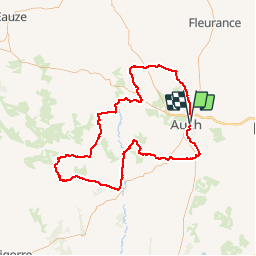
Trail Bicycle tourism of 129 km to be discovered at Occitania, Gers, Auch. This trail is proposed by potofe.

Description

Le circuit part d''Auch, capitale du département, riche en vestiges du passé. La Cathédrale Sainte-Marie, classée au patrimoine mondial de l''UNESCO, d''un gothique flamboyant avec ses vitraux d''Arnaud-de-Moles et ses stalles richement sculptées.
La préfecture, ancien évêché dont la façade est ornée de pilastres cannelés d''ordre corinthien, la Tour d''Armagnac ainsi que la statue de d''Artagnan dominent l''escalier monumental.

Ne manquez pas de visiter les pousterles, ruelles très étroites et pittoresques en escalier abrupt, qui relient la haute ville à la vallée du Gers.

Au coeur de la Gascogne, cet itinéraire vous invite à la découverte des bastides (Pavie, Mirande, Bassoues avec son donjon, Jegun...) et des pittoresques villages perchés (Lavardens et son imposant château, lieu de nombreuses expositions, Ordan-Larroque, village fleuri 4 fleurs, Roquelaure...).

Elevation profile

Positioning

Country:
France
Region :
Occitania
Department/Province :
Gers
Municipality :
Auch
Location:
Unknown
Start:(UTM)
306124 ; 4835446 (31T) N.

Trails nearby

Trail Walking Duran - Rando arbre 2023 - Photo
Walking
papounet32

Walking

Medium
Duran, Occitania, Gers, France
9.1 km | 11.2 km-effort
2h 13min
Yes
Trail Walking Duran - GRP Coeur de Gascogne - Photo
Walking
papounet32

Walking

Difficult
Duran, Occitania, Gers, France
13.1 km | 17.1 km-effort
3h 52min
No
Trail Walking Auch - 32-01-Au Cœur de Gascogne Auch-29km- 102-5537  - Photo
Walking
rvs147

Walking

Medium
Auch, Occitania, Gers, France
29 km | 37 km-effort
7h 58min
No
Trail Walking Pavie - Autour de Pavie - Photo
Walking
tracegps

Walking

Medium
Pavie, Occitania, Gers, France
7.5 km | 9.3 km-effort
2h 0min
Yes
Trail Walking Auch - 32-00-Au Cœur de Gascogne 15km - Photo
Walking
rvs147

Walking

Medium
Auch, Occitania, Gers, France
153 km | 192 km-effort
7min
Yes
Trail Walking Pavie - Pavie PR2 - Photo
Walking
lataboge

Walking

Easy
Pavie, Occitania, Gers, France
9.8 km | 11.9 km-effort
Unknown
Yes
Trail Walking Pavie - Pavie - Photo
Walking
Pascal Bernaud

Walking

Difficult
Pavie, Occitania, Gers, France
10.8 km | 14.1 km-effort
3h 4min
Yes
Trail Walking Duran - Boucle duran - Photo
Walking
papounet32

Walking

Duran, Occitania, Gers, France
9.3 km | 12.2 km-effort
2h 27min
No
Trail Walking Auch - 10km du 32 - Photo
Walking
papounet32

Walking

Auch, Occitania, Gers, France
12.6 km | 15.6 km-effort
3h 15min
No


Close
My subscriptions