


Camp Turenne par st Antoine

Derrendinger
User
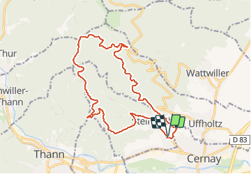

Length
17.6 km

Max alt
952 m

Uphill gradient
746 m
Km-Effort
28 km

Min alt
323 m

Downhill gradient
747 m
Boucle
Yes
Creation date :
2018-01-21 10:53:47.697
Updated on :
2019-01-16 10:38:35.144
1h40
Difficulty : Medium

FREE GPS app for hiking
 SityTrail
IGN / Geographical institutes
SityTrail Plus
The world is yours!
About
Trail Mountain bike of 17.6 km to be discovered at Grand Est, Haut-Rhin, Steinbach. This trail is proposed by Derrendinger.
Description
Belle montée avec un petit passage étroit vers la source st Antoine
Positioning
Country:
France
Region :
Grand Est
Department/Province :
Haut-Rhin
Municipality :
Steinbach
Location:
Unknown
Start:(Dec)
Start:(UTM)
362319 ; 5297470 (32T) N.
Comments