


Munster - Ried - Solberg

jpbeeckman
User
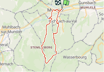

Length
14 km

Max alt
937 m

Uphill gradient
635 m
Km-Effort
22 km

Min alt
366 m

Downhill gradient
635 m
Boucle
Yes
Creation date :
2018-05-30 16:14:40.798
Updated on :
2018-05-30 16:22:04.828
4h37
Difficulty : Very difficult

FREE GPS app for hiking
 SityTrail
IGN / Geographical institutes
SityTrail Plus
The world is yours!
About
Trail Walking of 14 km to be discovered at Grand Est, Haut-Rhin, Munster. This trail is proposed by jpbeeckman.
Description
Découverte des hauteurs de Munster
Photos


Positioning
Country:
France
Region :
Grand Est
Department/Province :
Haut-Rhin
Municipality :
Munster
Location:
Unknown
Start:(Dec)
Start:(UTM)
361745 ; 5322598 (32U) N.
Comments