


Refuge du Mont Thabor

jpb83
User
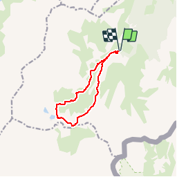

Length
9.9 km

Max alt
2498 m

Uphill gradient
555 m
Km-Effort
17.3 km

Min alt
1943 m

Downhill gradient
554 m
Boucle
Yes
Creation date :
2018-07-27 16:04:58.137
Updated on :
2018-07-27 16:05:46.812
3h31
Difficulty : Difficult

FREE GPS app for hiking
 SityTrail
IGN / Geographical institutes
SityTrail Plus
The world is yours!
About
Trail Walking of 9.9 km to be discovered at Auvergne-Rhône-Alpes, Savoy, Modane. This trail is proposed by jpb83.
Positioning
Country:
France
Region :
Auvergne-Rhône-Alpes
Department/Province :
Savoy
Municipality :
Modane
Location:
Unknown
Start:(Dec)
Start:(UTM)
313746 ; 5002004 (32T) N.
Comments