


tigne et le lac du chevril

ocepee
User
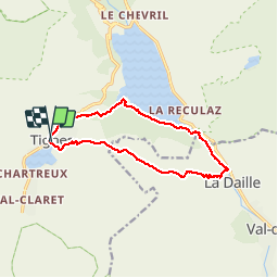

Length
12.7 km

Max alt
2278 m

Uphill gradient
670 m
Km-Effort
22 km

Min alt
1765 m

Downhill gradient
669 m
Boucle
Yes
Creation date :
2018-08-05 08:19:10.218
Updated on :
2018-08-05 17:00:08.939
5h09
Difficulty : Medium

FREE GPS app for hiking
 SityTrail
IGN / Geographical institutes
SityTrail Plus
The world is yours!
About
Trail Walking of 12.7 km to be discovered at Auvergne-Rhône-Alpes, Savoy, Tignes. This trail is proposed by ocepee.
Description
Chouette rando avec une magnifique vue du lac !
Photos


Positioning
Country:
France
Region :
Auvergne-Rhône-Alpes
Department/Province :
Savoy
Municipality :
Tignes
Location:
Unknown
Start:(Dec)
Start:(UTM)
336391 ; 5037196 (32T) N.
Comments