


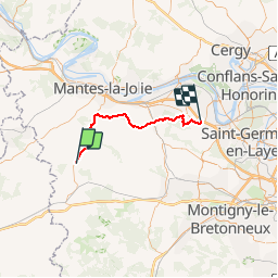

15.8 km | 19.7 km-effort


partout a pied et en moto


FREE GPS app for hiking
 SityTrail
IGN / Geographical institutes
SityTrail World
The world is yours!
Trail Walking of 39 km to be discovered at Ile-de-France, Yvelines, Orvilliers. This trail is proposed by les randos d'Olivier.

Walking

Walking

Running
Mountain bike

Walking
Walking

Walking
Walking

Mountain bike