Autopedestres : Itzig

Visit Luxembourg
Randonnées de Visit Luxembourg. GUIDE+
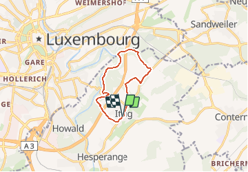

Length
8.3 km

Max alt
341 m

Uphill gradient
188 m
Km-Effort
10.8 km

Min alt
262 m

Downhill gradient
192 m
Boucle
Yes
Creation date :
2014-12-10 00:00:00.0
Updated on :
2014-12-10 00:00:00.0
--
Difficulty : Unknown

FREE GPS app for hiking
 SityTrail
IGN / Geographical institutes
SityTrail Plus
The world is yours!
About
Trail Walking of 8.3 km to be discovered at Unknown, Canton Luxembourg, Hesperange. This trail is proposed by Visit Luxembourg.


Positioning
Country:
Luxembourg
Region :
Unknown
Department/Province :
Canton Luxembourg
Municipality :
Hesperange
Location:
Unknown
Start:(Dec)
Start:(UTM)
295590 ; 5496449 (32U) N.
Comments