


Chaumes du Markstein

patrickbeyrath
User
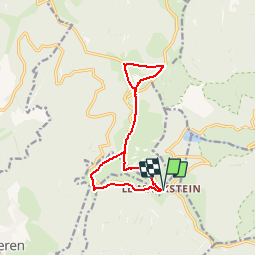

Length
11.5 km

Max alt
1276 m

Uphill gradient
299 m
Km-Effort
15.5 km

Min alt
1137 m

Downhill gradient
300 m
Boucle
Yes
Creation date :
2018-09-14 06:04:25.087
Updated on :
2018-09-14 06:30:08.706
2h04
Difficulty : Medium

FREE GPS app for hiking
 SityTrail
IGN / Geographical institutes
SityTrail Plus
The world is yours!
About
Trail Walking of 11.5 km to be discovered at Grand Est, Haut-Rhin, Fellering. This trail is proposed by patrickbeyrath.
Positioning
Country:
France
Region :
Grand Est
Department/Province :
Haut-Rhin
Municipality :
Fellering
Location:
Unknown
Start:(Dec)
Start:(UTM)
353044 ; 5309629 (32T) N.
Comments