


betharam RS

LouisROGER
User GUIDE
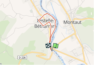

Length
2.7 km

Max alt
317 m

Uphill gradient
30 m
Km-Effort
3.1 km

Min alt
296 m

Downhill gradient
30 m
Boucle
Yes
Creation date :
2018-10-01 08:19:54.838
Updated on :
2018-10-01 08:20:54.515
40m
Difficulty : Easy

FREE GPS app for hiking
 SityTrail
IGN / Geographical institutes
SityTrail Plus
The world is yours!
About
Trail Walking of 2.7 km to be discovered at New Aquitaine, Pyrénées-Atlantiques, Lestelle-Bétharram. This trail is proposed by LouisROGER.
Positioning
Country:
France
Region :
New Aquitaine
Department/Province :
Pyrénées-Atlantiques
Municipality :
Lestelle-Bétharram
Location:
Unknown
Start:(Dec)
Start:(UTM)
727228 ; 4778233 (30T) N.
Comments