


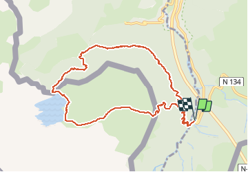
Lac d’Estaens

611686735
User

Length
11.8 km

Max alt
1803 m

Uphill gradient
638 m
Km-Effort
20 km

Min alt
1317 m

Downhill gradient
637 m
Boucle
Yes
Creation date :
2018-10-13 07:23:44.0
Updated on :
2018-10-13 15:57:43.406
6h48
Difficulty : Medium

FREE GPS app for hiking
 SityTrail
IGN / Geographical institutes
SityTrail Plus
The world is yours!
About
Trail Walking of 11.8 km to be discovered at New Aquitaine, Pyrénées-Atlantiques, Urdos. This trail is proposed by 611686735.
Positioning
Country:
France
Region :
New Aquitaine
Department/Province :
Pyrénées-Atlantiques
Municipality :
Urdos
Location:
Unknown
Start:(Dec)
Start:(UTM)
699958 ; 4741243 (30T) N.
Comments