


2018 toussain J02

Airelle
User
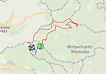

Length
15.9 km

Max alt
1187 m

Uphill gradient
881 m
Km-Effort
28 km

Min alt
816 m

Downhill gradient
868 m
Boucle
Yes
Creation date :
2018-10-18 17:09:20.203
Updated on :
2018-10-18 17:26:28.822
1h34
Difficulty : Medium

FREE GPS app for hiking
 SityTrail
IGN / Geographical institutes
SityTrail Plus
The world is yours!
About
Trail Walking of 15.9 km to be discovered at Grand Est, Haut-Rhin, Oberbruck. This trail is proposed by Airelle.
Positioning
Country:
France
Region :
Grand Est
Department/Province :
Haut-Rhin
Municipality :
Oberbruck
Location:
Unknown
Start:(Dec)
Start:(UTM)
342908 ; 5298953 (32T) N.
Comments