


Col du Wettstein - Lac Vert - Lac du Forlet

patrickbeyrath
User
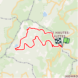

Length
13.7 km

Max alt
1175 m

Uphill gradient
458 m
Km-Effort
19.8 km

Min alt
852 m

Downhill gradient
459 m
Boucle
Yes
Creation date :
2018-10-19 05:16:15.484
Updated on :
2018-10-19 06:03:56.939
4h25
Difficulty : Medium

FREE GPS app for hiking
 SityTrail
IGN / Geographical institutes
SityTrail Plus
The world is yours!
About
Trail Walking of 13.7 km to be discovered at Grand Est, Haut-Rhin, Orbey. This trail is proposed by patrickbeyrath.
Description
Col du Wettstein - Musmiss - Rappenkopf - Lac Vert - Abri près Erichson- Lac du Forlet et retour par rond jaune les Hautes Huttes et GR 532 Col du Wettstein
Positioning
Country:
France
Region :
Grand Est
Department/Province :
Haut-Rhin
Municipality :
Orbey
Location:
Unknown
Start:(Dec)
Start:(UTM)
359714 ; 5327786 (32U) N.
Comments